You are here: Home > Network List > TA - USArray Transportable Network (new EarthScope stations) Stations List
> Station T48A Bowling Green, KY, USA > Earthquake Result Viewer
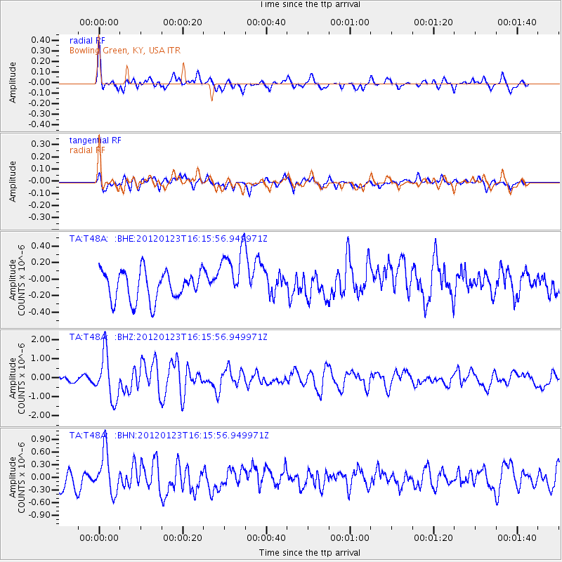
T48A Bowling Green, KY, USA - Earthquake Result Viewer
*The percent match for this event was below the threshold and hence no stack was calculated.
| Earthquake location: |
Near Coast Of Central Chile |
| Earthquake latitude/longitude: |
-36.4/-73.0 |
| Earthquake time(UTC): |
2012/01/23 (023) 16:04:52 GMT |
| Earthquake Depth: |
20 km |
| Earthquake Magnitude: |
5.8 MB, 6.0 MS, 6.1 MW, 6.2 MW |
| Earthquake Catalog/Contributor: |
WHDF/NEIC |
|
| Network: |
TA USArray Transportable Network (new EarthScope stations) |
| Station: |
T48A Bowling Green, KY, USA |
| Lat/Lon: |
37.11 N/86.39 W |
| Elevation: |
218 m |
|
| Distance: |
74.2 deg |
| Az: |
348.928 deg |
| Baz: |
168.826 deg |
| Ray Param: |
$rayparam |
*The percent match for this event was below the threshold and hence was not used in the summary stack. |
|
| Radial Match: |
63.110886 % |
| Radial Bump: |
400 |
| Transverse Match: |
50.870705 % |
| Transverse Bump: |
400 |
| SOD ConfigId: |
436445 |
| Insert Time: |
2012-04-05 16:27:19.493 +0000 |
| GWidth: |
2.5 |
| Max Bumps: |
400 |
| Tol: |
0.001 |
|
Signal To Noise
| Channel | StoN | STA | LTA |
| TA:T48A: :BHZ:20120123T16:15:56.949971Z | 5.204917 | 1.2237903E-6 | 2.3512196E-7 |
| TA:T48A: :BHN:20120123T16:15:56.949971Z | 2.6691723 | 5.0470175E-7 | 1.8908547E-7 |
| TA:T48A: :BHE:20120123T16:15:56.949971Z | 1.9030819 | 3.358359E-7 | 1.764695E-7 |
| Arrivals |
| Ps | |
| PpPs | |
| PsPs/PpSs | |


