You are here: Home > Network List > AU - Australian Seismological Centre Stations List
> Station QIS Mount Isa, Queensland > Earthquake Result Viewer
QIS Mount Isa, Queensland - Earthquake Result Viewer
| Earthquake location: |
South Of Fiji Islands |
| Earthquake latitude/longitude: |
-25.0/178.5 |
| Earthquake time(UTC): |
2012/01/24 (024) 00:52:05 GMT |
| Earthquake Depth: |
580 km |
| Earthquake Magnitude: |
5.8 MB, 6.3 MW, 6.4 MW |
| Earthquake Catalog/Contributor: |
WHDF/NEIC |
|
| Network: |
AU Australian Seismological Centre |
| Station: |
QIS Mount Isa, Queensland |
| Lat/Lon: |
20.56 S/139.61 E |
| Elevation: |
450 m |
|
| Distance: |
36.1 deg |
| Az: |
268.965 deg |
| Baz: |
104.459 deg |
| Ray Param: |
0.0739466 |
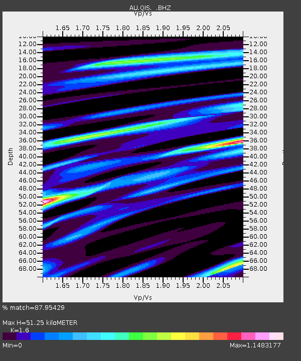
| Estimated Moho Depth: |
51.25 km |
| Estimated Crust Vp/Vs: |
1.60 |
| Assumed Crust Vp: |
6.577 km/s |
| Estimated Crust Vs: |
4.111 km/s |
| Estimated Crust Poisson's Ratio: |
0.18 |
|
| Radial Match: |
87.95429 % |
| Radial Bump: |
239 |
| Transverse Match: |
75.59315 % |
| Transverse Bump: |
400 |
| SOD ConfigId: |
436445 |
| Insert Time: |
2012-04-05 16:34:45.033 +0000 |
| GWidth: |
2.5 |
| Max Bumps: |
400 |
| Tol: |
0.001 |
|

Signal To Noise
| Channel | StoN | STA | LTA |
| AU:QIS: :BHZ:20120124T00:57:48.46999Z | 18.787453 | 4.5580996E-6 | 2.4261405E-7 |
| AU:QIS: :BHN:20120124T00:57:48.46999Z | 1.2080071 | 2.4929534E-7 | 2.0636911E-7 |
| AU:QIS: :BHE:20120124T00:57:48.46999Z | 18.984676 | 3.1408626E-6 | 1.6544199E-7 |
| Arrivals |
| Ps | 5.1 SECOND |
| PpPs | 19 SECOND |
| PsPs/PpSs | 24 SECOND |


