You are here: Home > Network List > AZ - ANZA Regional Network Stations List
> Station LVA2 AZ.LVA2 > Earthquake Result Viewer
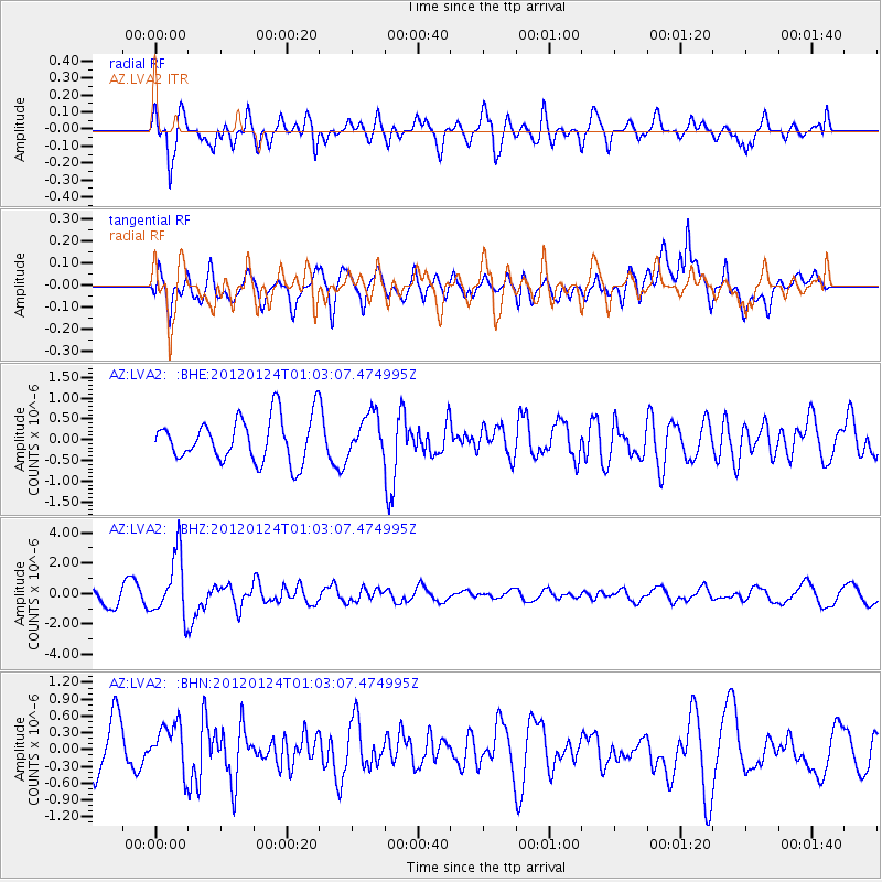
LVA2 AZ.LVA2 - Earthquake Result Viewer
*The percent match for this event was below the threshold and hence no stack was calculated.
| Earthquake location: |
South Of Fiji Islands |
| Earthquake latitude/longitude: |
-25.0/178.5 |
| Earthquake time(UTC): |
2012/01/24 (024) 00:52:05 GMT |
| Earthquake Depth: |
580 km |
| Earthquake Magnitude: |
5.8 MB, 6.3 MW, 6.4 MW |
| Earthquake Catalog/Contributor: |
WHDF/NEIC |
|
| Network: |
AZ ANZA Regional Network |
| Station: |
LVA2 AZ.LVA2 |
| Lat/Lon: |
33.35 N/116.56 W |
| Elevation: |
1435 m |
|
| Distance: |
84.7 deg |
| Az: |
49.581 deg |
| Baz: |
235.639 deg |
| Ray Param: |
$rayparam |
*The percent match for this event was below the threshold and hence was not used in the summary stack. |
|
| Radial Match: |
71.00551 % |
| Radial Bump: |
400 |
| Transverse Match: |
71.785355 % |
| Transverse Bump: |
400 |
| SOD ConfigId: |
436445 |
| Insert Time: |
2012-04-05 16:37:15.849 +0000 |
| GWidth: |
2.5 |
| Max Bumps: |
400 |
| Tol: |
0.001 |
|
Signal To Noise
| Channel | StoN | STA | LTA |
| AZ:LVA2: :BHZ:20120124T01:03:07.474995Z | 4.3730326 | 2.0451305E-6 | 4.676687E-7 |
| AZ:LVA2: :BHN:20120124T01:03:07.474995Z | 1.3956169 | 4.1601083E-7 | 2.9808382E-7 |
| AZ:LVA2: :BHE:20120124T01:03:07.474995Z | 0.9368599 | 4.967744E-7 | 5.3025474E-7 |
| Arrivals |
| Ps | |
| PpPs | |
| PsPs/PpSs | |


