You are here: Home > Network List > CI - Caltech Regional Seismic Network Stations List
> Station MPM Manuel Prospect Mine, California, USA > Earthquake Result Viewer
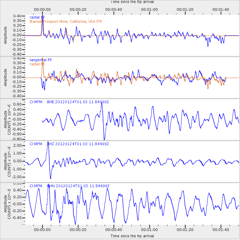
MPM Manuel Prospect Mine, California, USA - Earthquake Result Viewer
*The percent match for this event was below the threshold and hence no stack was calculated.
| Earthquake location: |
South Of Fiji Islands |
| Earthquake latitude/longitude: |
-25.0/178.5 |
| Earthquake time(UTC): |
2012/01/24 (024) 00:52:05 GMT |
| Earthquake Depth: |
580 km |
| Earthquake Magnitude: |
5.8 MB, 6.3 MW, 6.4 MW |
| Earthquake Catalog/Contributor: |
WHDF/NEIC |
|
| Network: |
CI Caltech Regional Seismic Network |
| Station: |
MPM Manuel Prospect Mine, California, USA |
| Lat/Lon: |
36.06 N/117.49 W |
| Elevation: |
185 m |
|
| Distance: |
85.6 deg |
| Az: |
46.917 deg |
| Baz: |
234.889 deg |
| Ray Param: |
$rayparam |
*The percent match for this event was below the threshold and hence was not used in the summary stack. |
|
| Radial Match: |
66.5699 % |
| Radial Bump: |
376 |
| Transverse Match: |
60.35681 % |
| Transverse Bump: |
384 |
| SOD ConfigId: |
436445 |
| Insert Time: |
2012-04-05 16:39:30.649 +0000 |
| GWidth: |
2.5 |
| Max Bumps: |
400 |
| Tol: |
0.001 |
|
Signal To Noise
| Channel | StoN | STA | LTA |
| CI:MPM: :BHZ:20120124T01:03:11.84499Z | 5.944819 | 1.2180808E-6 | 2.0489787E-7 |
| CI:MPM: :BHN:20120124T01:03:11.84499Z | 1.4319874 | 2.9852276E-7 | 2.0846747E-7 |
| CI:MPM: :BHE:20120124T01:03:11.84499Z | 2.1649282 | 3.672037E-7 | 1.6961474E-7 |
| Arrivals |
| Ps | |
| PpPs | |
| PsPs/PpSs | |


