You are here: Home > Network List > GT - Global Telemetered Seismograph Network (USAF/USGS) Stations List
> Station PLCA Paso Flores, Argentina > Earthquake Result Viewer
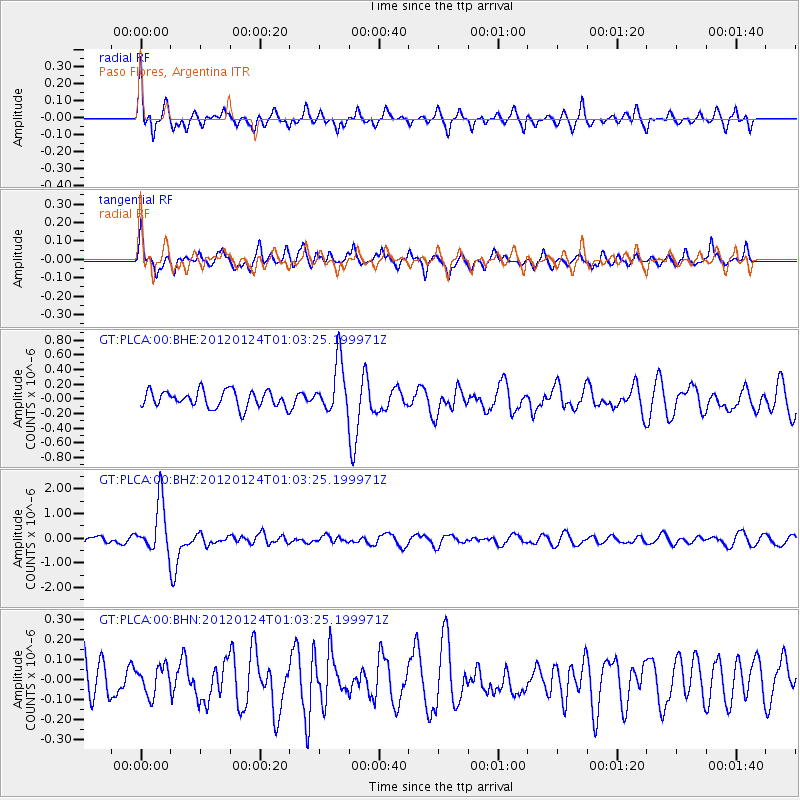
PLCA Paso Flores, Argentina - Earthquake Result Viewer
*The percent match for this event was below the threshold and hence no stack was calculated.
| Earthquake location: |
South Of Fiji Islands |
| Earthquake latitude/longitude: |
-25.0/178.5 |
| Earthquake time(UTC): |
2012/01/24 (024) 00:52:05 GMT |
| Earthquake Depth: |
580 km |
| Earthquake Magnitude: |
5.8 MB, 6.3 MW, 6.4 MW |
| Earthquake Catalog/Contributor: |
WHDF/NEIC |
|
| Network: |
GT Global Telemetered Seismograph Network (USAF/USGS) |
| Station: |
PLCA Paso Flores, Argentina |
| Lat/Lon: |
40.73 S/70.55 W |
| Elevation: |
1050 m |
|
| Distance: |
88.5 deg |
| Az: |
134.762 deg |
| Baz: |
237.993 deg |
| Ray Param: |
$rayparam |
*The percent match for this event was below the threshold and hence was not used in the summary stack. |
|
| Radial Match: |
70.54166 % |
| Radial Bump: |
400 |
| Transverse Match: |
76.41556 % |
| Transverse Bump: |
400 |
| SOD ConfigId: |
436445 |
| Insert Time: |
2012-04-05 16:43:09.954 +0000 |
| GWidth: |
2.5 |
| Max Bumps: |
400 |
| Tol: |
0.001 |
|
Signal To Noise
| Channel | StoN | STA | LTA |
| GT:PLCA:00:BHZ:20120124T01:03:25.199971Z | 7.45433 | 1.0334766E-6 | 1.386411E-7 |
| GT:PLCA:00:BHN:20120124T01:03:25.199971Z | 0.7229742 | 7.007812E-8 | 9.693032E-8 |
| GT:PLCA:00:BHE:20120124T01:03:25.199971Z | 3.0528893 | 3.4689666E-7 | 1.1362896E-7 |
| Arrivals |
| Ps | |
| PpPs | |
| PsPs/PpSs | |


