You are here: Home > Network List > UW - Pacific Northwest Regional Seismic Network Stations List
> Station UMAT Pilot Rock, OR, USA > Earthquake Result Viewer
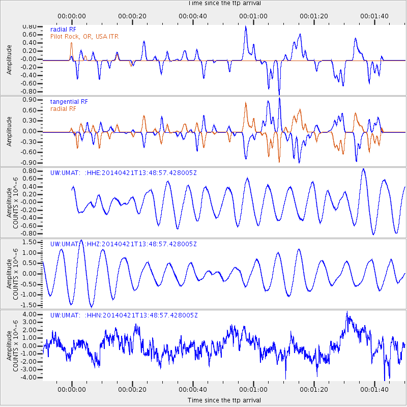
UMAT Pilot Rock, OR, USA - Earthquake Result Viewer
*The percent match for this event was below the threshold and hence no stack was calculated.
| Earthquake location: |
Tonga Islands |
| Earthquake latitude/longitude: |
-20.2/-173.2 |
| Earthquake time(UTC): |
2014/04/21 (111) 13:37:14 GMT |
| Earthquake Depth: |
47 km |
| Earthquake Magnitude: |
5.0 MW |
| Earthquake Catalog/Contributor: |
ISC/ISC |
|
| Network: |
UW Pacific Northwest Regional Seismic Network |
| Station: |
UMAT Pilot Rock, OR, USA |
| Lat/Lon: |
45.29 N/118.96 W |
| Elevation: |
1318 m |
|
| Distance: |
81.7 deg |
| Az: |
35.373 deg |
| Baz: |
230.363 deg |
| Ray Param: |
$rayparam |
*The percent match for this event was below the threshold and hence was not used in the summary stack. |
|
| Radial Match: |
31.785322 % |
| Radial Bump: |
400 |
| Transverse Match: |
24.808487 % |
| Transverse Bump: |
400 |
| SOD ConfigId: |
3390531 |
| Insert Time: |
2019-04-11 13:57:23.934 +0000 |
| GWidth: |
2.5 |
| Max Bumps: |
400 |
| Tol: |
0.001 |
|
Signal To Noise
| Channel | StoN | STA | LTA |
| UW:UMAT: :HHZ:20140421T13:48:57.428005Z | 3.426908 | 1.1474087E-6 | 3.348233E-7 |
| UW:UMAT: :HHN:20140421T13:48:57.428005Z | 0.6158897 | 6.8833117E-7 | 1.1176209E-6 |
| UW:UMAT: :HHE:20140421T13:48:57.428005Z | 2.419145 | 3.9048652E-7 | 1.6141509E-7 |
| Arrivals |
| Ps | |
| PpPs | |
| PsPs/PpSs | |


