You are here: Home > Network List > TA - USArray Transportable Network (new EarthScope stations) Stations List
> Station Q24A Divide, CO, USA > Earthquake Result Viewer
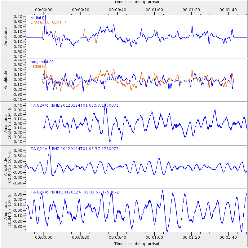
Q24A Divide, CO, USA - Earthquake Result Viewer
*The percent match for this event was below the threshold and hence no stack was calculated.
| Earthquake location: |
South Of Fiji Islands |
| Earthquake latitude/longitude: |
-25.0/178.5 |
| Earthquake time(UTC): |
2012/01/24 (024) 00:52:05 GMT |
| Earthquake Depth: |
580 km |
| Earthquake Magnitude: |
5.8 MB, 6.3 MW, 6.4 MW |
| Earthquake Catalog/Contributor: |
WHDF/NEIC |
|
| Network: |
TA USArray Transportable Network (new EarthScope stations) |
| Station: |
Q24A Divide, CO, USA |
| Lat/Lon: |
38.96 N/105.15 W |
| Elevation: |
2775 m |
|
| Distance: |
95.5 deg |
| Az: |
49.554 deg |
| Baz: |
242.366 deg |
| Ray Param: |
$rayparam |
*The percent match for this event was below the threshold and hence was not used in the summary stack. |
|
| Radial Match: |
54.532997 % |
| Radial Bump: |
400 |
| Transverse Match: |
51.611523 % |
| Transverse Bump: |
400 |
| SOD ConfigId: |
436445 |
| Insert Time: |
2012-04-05 16:47:32.361 +0000 |
| GWidth: |
2.5 |
| Max Bumps: |
400 |
| Tol: |
0.001 |
|
Signal To Noise
| Channel | StoN | STA | LTA |
| TA:Q24A: :BHZ:20120124T01:03:57.175007Z | 3.6400554 | 4.806411E-7 | 1.3204225E-7 |
| TA:Q24A: :BHN:20120124T01:03:57.175007Z | 1.578396 | 1.6633959E-7 | 1.05385205E-7 |
| TA:Q24A: :BHE:20120124T01:03:57.175007Z | 2.4208322 | 2.1724608E-7 | 8.974025E-8 |
| Arrivals |
| Ps | |
| PpPs | |
| PsPs/PpSs | |


