You are here: Home > Network List > UW - Pacific Northwest Regional Seismic Network Stations List
> Station LEBA Lebam, WA, USA > Earthquake Result Viewer
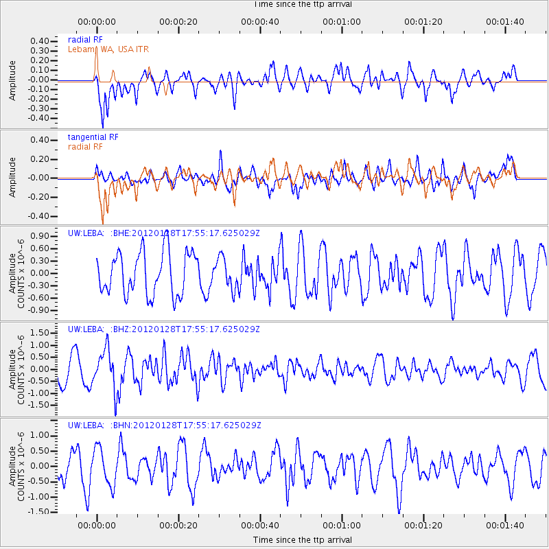
LEBA Lebam, WA, USA - Earthquake Result Viewer
*The percent match for this event was below the threshold and hence no stack was calculated.
| Earthquake location: |
Kermadec Islands, New Zealand |
| Earthquake latitude/longitude: |
-29.4/-177.4 |
| Earthquake time(UTC): |
2012/01/28 (028) 17:42:51 GMT |
| Earthquake Depth: |
21 km |
| Earthquake Magnitude: |
5.8 MB, 5.6 MS, 5.9 MW, 5.8 MW |
| Earthquake Catalog/Contributor: |
WHDF/NEIC |
|
| Network: |
UW Pacific Northwest Regional Seismic Network |
| Station: |
LEBA Lebam, WA, USA |
| Lat/Lon: |
46.55 N/123.56 W |
| Elevation: |
73 m |
|
| Distance: |
89.9 deg |
| Az: |
33.858 deg |
| Baz: |
224.762 deg |
| Ray Param: |
$rayparam |
*The percent match for this event was below the threshold and hence was not used in the summary stack. |
|
| Radial Match: |
46.33206 % |
| Radial Bump: |
400 |
| Transverse Match: |
46.37631 % |
| Transverse Bump: |
400 |
| SOD ConfigId: |
436445 |
| Insert Time: |
2012-04-05 17:32:38.513 +0000 |
| GWidth: |
2.5 |
| Max Bumps: |
400 |
| Tol: |
0.001 |
|
Signal To Noise
| Channel | StoN | STA | LTA |
| UW:LEBA: :BHZ:20120128T17:55:17.625029Z | 2.1329985 | 8.2849283E-7 | 3.88417E-7 |
| UW:LEBA: :BHN:20120128T17:55:17.625029Z | 1.1764718 | 6.092223E-7 | 5.1783843E-7 |
| UW:LEBA: :BHE:20120128T17:55:17.625029Z | 0.74715537 | 3.8663586E-7 | 5.174772E-7 |
| Arrivals |
| Ps | |
| PpPs | |
| PsPs/PpSs | |


