You are here: Home > Network List > AE - Arizona Broadband Seismic Network Stations List
> Station W13A Hualapai Mountain Park, Kingman, AZ, USA > Earthquake Result Viewer
W13A Hualapai Mountain Park, Kingman, AZ, USA - Earthquake Result Viewer
| Earthquake location: |
Near Coast Of Peru |
| Earthquake latitude/longitude: |
-14.2/-75.6 |
| Earthquake time(UTC): |
2012/01/30 (030) 05:11:00 GMT |
| Earthquake Depth: |
43 km |
| Earthquake Magnitude: |
6.3 MB, 5.9 MS, 6.4 MW, 6.4 MW |
| Earthquake Catalog/Contributor: |
WHDF/NEIC |
|
| Network: |
AE Arizona Broadband Seismic Network |
| Station: |
W13A Hualapai Mountain Park, Kingman, AZ, USA |
| Lat/Lon: |
35.10 N/113.89 W |
| Elevation: |
1988 m |
|
| Distance: |
61.0 deg |
| Az: |
324.506 deg |
| Baz: |
136.62 deg |
| Ray Param: |
0.061096415 |
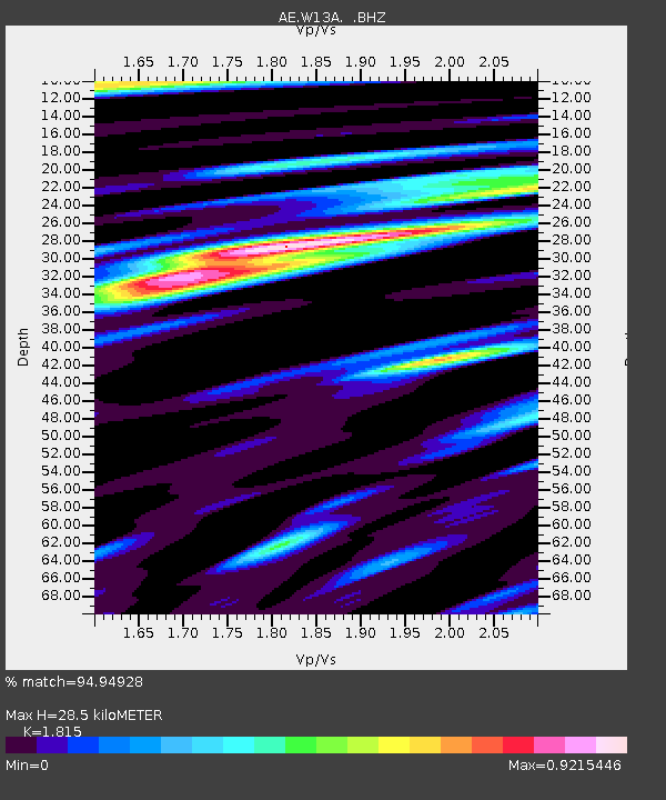
| Estimated Moho Depth: |
28.5 km |
| Estimated Crust Vp/Vs: |
1.82 |
| Assumed Crust Vp: |
6.276 km/s |
| Estimated Crust Vs: |
3.458 km/s |
| Estimated Crust Poisson's Ratio: |
0.28 |
|
| Radial Match: |
94.94928 % |
| Radial Bump: |
363 |
| Transverse Match: |
81.93708 % |
| Transverse Bump: |
400 |
| SOD ConfigId: |
436445 |
| Insert Time: |
2012-04-11 04:27:40.593 +0000 |
| GWidth: |
2.5 |
| Max Bumps: |
400 |
| Tol: |
0.001 |
|

Signal To Noise
| Channel | StoN | STA | LTA |
| AE:W13A: :BHZ:20120130T05:20:38.999988Z | 5.1034217 | 7.4537394E-7 | 1.4605376E-7 |
| AE:W13A: :BHN:20120130T05:20:38.999988Z | 3.2888293 | 2.5326446E-7 | 7.700748E-8 |
| AE:W13A: :BHE:20120130T05:20:38.999988Z | 1.8704877 | 2.5699882E-7 | 1.373967E-7 |
| Arrivals |
| Ps | 3.9 SECOND |
| PpPs | 12 SECOND |
| PsPs/PpSs | 16 SECOND |


