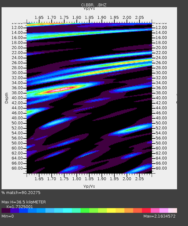
BBR Big Bear Solar Observatory - Earthquake Result Viewer

Earthquake location: Near Coast Of Peru
Earthquake latitude/longitude: -14.2/-75.6
Earthquake time(UTC): 2012/01/30 (030) 05:11:00 GMT
Earthquake Depth: 43 km
Earthquake Magnitude: 6.3 MB, 5.9 MS, 6.4 MW, 6.4 MW
Earthquake Catalog/Contributor: WHDF/NEIC
Network: CI Caltech Regional Seismic Network
Station: BBR Big Bear Solar Observatory
Lat/Lon: 34.26 N/116.92 W
Elevation: 2069 m
Distance: 62.1 deg
Az: 321.82 deg
Baz: 133.62 deg
Ray Param: 0.060337838
Estimated Moho Depth: 36.5 km
Estimated Crust Vp/Vs: 1.73
Assumed Crust Vp: 6.276 km/s
Estimated Crust Vs: 3.622 km/s
Estimated Crust Poisson's Ratio: 0.25
Radial Match: 90.20275 %
Radial Bump: 400
Transverse Match: 84.11158 %
Transverse Bump: 400
SOD ConfigId: 436445
Insert Time: 2012-04-11 04:39:41.867 +0000
GWidth: 2.5
Max Bumps: 400
Tol: 0.001

Signal To Noise

ChannelStoNSTALTA
CI:BBR: :BHZ:20120130T05:20:46.895007Z8.0772561.2313369E-61.5244495E-7
CI:BBR: :BHN:20120130T05:20:46.895007Z11.9046116.397867E-75.3742767E-8
CI:BBR: :BHE:20120130T05:20:46.895007Z4.62046585.9728416E-71.2926925E-7
Arrivals
Ps4.4 SECOND
PpPs15 SECOND
PsPs/PpSs20 SECOND