You are here: Home > Network List > CI - Caltech Regional Seismic Network Stations List
> Station MPP McPhearson Peak > Earthquake Result Viewer
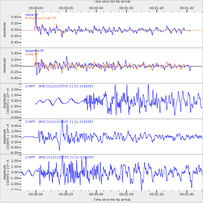
MPP McPhearson Peak - Earthquake Result Viewer
*The percent match for this event was below the threshold and hence no stack was calculated.
| Earthquake location: |
Near Coast Of Peru |
| Earthquake latitude/longitude: |
-14.2/-75.6 |
| Earthquake time(UTC): |
2012/01/30 (030) 05:11:00 GMT |
| Earthquake Depth: |
43 km |
| Earthquake Magnitude: |
6.3 MB, 5.9 MS, 6.4 MW, 6.4 MW |
| Earthquake Catalog/Contributor: |
WHDF/NEIC |
|
| Network: |
CI Caltech Regional Seismic Network |
| Station: |
MPP McPhearson Peak |
| Lat/Lon: |
34.89 N/119.81 W |
| Elevation: |
1739 m |
|
| Distance: |
64.3 deg |
| Az: |
320.529 deg |
| Baz: |
131.404 deg |
| Ray Param: |
$rayparam |
*The percent match for this event was below the threshold and hence was not used in the summary stack. |
|
| Radial Match: |
71.44459 % |
| Radial Bump: |
400 |
| Transverse Match: |
76.426445 % |
| Transverse Bump: |
400 |
| SOD ConfigId: |
436445 |
| Insert Time: |
2012-04-11 04:40:16.236 +0000 |
| GWidth: |
2.5 |
| Max Bumps: |
400 |
| Tol: |
0.001 |
|
Signal To Noise
| Channel | StoN | STA | LTA |
| CI:MPP: :BHZ:20120130T05:21:01.319995Z | 3.3827806 | 1.1057547E-6 | 3.2687745E-7 |
| CI:MPP: :BHN:20120130T05:21:01.319995Z | 2.4209733 | 6.5419636E-7 | 2.702204E-7 |
| CI:MPP: :BHE:20120130T05:21:01.319995Z | 1.3173226 | 4.3857818E-7 | 3.329315E-7 |
| Arrivals |
| Ps | |
| PpPs | |
| PsPs/PpSs | |


