You are here: Home > Network List > LD - Lamont-Doherty Cooperative Seismographic Network Stations List
> Station ODNJ Ogdensburg, New Jersey > Earthquake Result Viewer
ODNJ Ogdensburg, New Jersey - Earthquake Result Viewer
| Earthquake location: |
Near Coast Of Peru |
| Earthquake latitude/longitude: |
-14.2/-75.6 |
| Earthquake time(UTC): |
2012/01/30 (030) 05:11:00 GMT |
| Earthquake Depth: |
43 km |
| Earthquake Magnitude: |
6.3 MB, 5.9 MS, 6.4 MW, 6.4 MW |
| Earthquake Catalog/Contributor: |
WHDF/NEIC |
|
| Network: |
LD Lamont-Doherty Cooperative Seismographic Network |
| Station: |
ODNJ Ogdensburg, New Jersey |
| Lat/Lon: |
41.08 N/74.61 W |
| Elevation: |
187 m |
|
| Distance: |
55.0 deg |
| Az: |
0.95 deg |
| Baz: |
181.219 deg |
| Ray Param: |
0.0650021 |
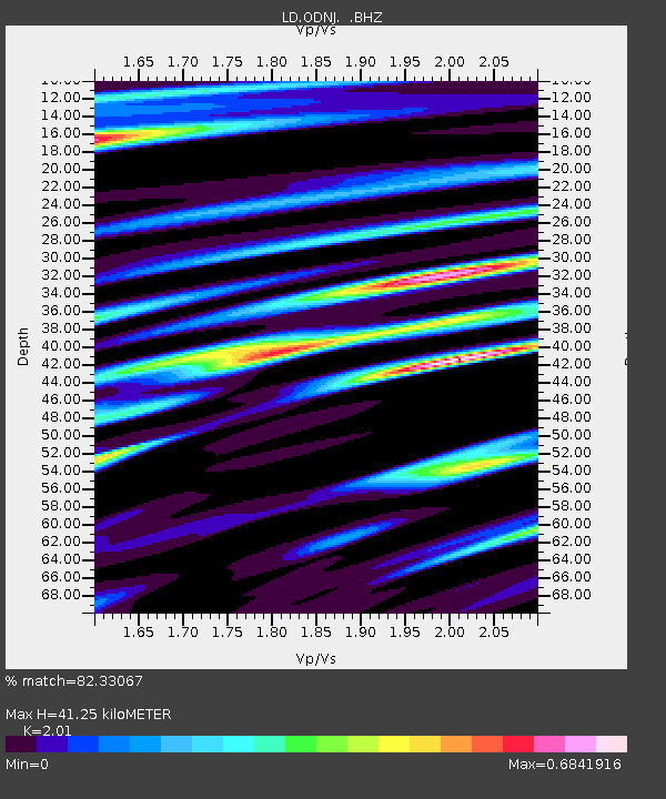
| Estimated Moho Depth: |
41.25 km |
| Estimated Crust Vp/Vs: |
2.01 |
| Assumed Crust Vp: |
6.283 km/s |
| Estimated Crust Vs: |
3.126 km/s |
| Estimated Crust Poisson's Ratio: |
0.34 |
|
| Radial Match: |
82.33067 % |
| Radial Bump: |
400 |
| Transverse Match: |
63.924217 % |
| Transverse Bump: |
400 |
| SOD ConfigId: |
436445 |
| Insert Time: |
2012-04-11 04:53:06.205 +0000 |
| GWidth: |
2.5 |
| Max Bumps: |
400 |
| Tol: |
0.001 |
|

Signal To Noise
| Channel | StoN | STA | LTA |
| LD:ODNJ: :BHZ:20120130T05:19:57.169971Z | 3.5362964 | 1.116973E-6 | 3.1585955E-7 |
| LD:ODNJ: :BHN:20120130T05:19:57.169971Z | 2.2477791 | 6.459602E-7 | 2.8737705E-7 |
| LD:ODNJ: :BHE:20120130T05:19:57.169971Z | 0.6823862 | 1.76171E-7 | 2.5816902E-7 |
| Arrivals |
| Ps | 6.9 SECOND |
| PpPs | 19 SECOND |
| PsPs/PpSs | 26 SECOND |


