You are here: Home > Network List > TA - USArray Transportable Network (new EarthScope stations) Stations List
> Station S36A Lake Cedric, Chanute, KS, USA > Earthquake Result Viewer
S36A Lake Cedric, Chanute, KS, USA - Earthquake Result Viewer

| Earthquake location: |
Near Coast Of Peru |
| Earthquake latitude/longitude: |
-14.2/-75.6 |
| Earthquake time(UTC): |
2012/01/30 (030) 05:11:00 GMT |
| Earthquake Depth: |
43 km |
| Earthquake Magnitude: |
6.3 MB, 5.9 MS, 6.4 MW, 6.4 MW |
| Earthquake Catalog/Contributor: |
WHDF/NEIC |
|
| Network: |
TA USArray Transportable Network (new EarthScope stations) |
| Station: |
S36A Lake Cedric, Chanute, KS, USA |
| Lat/Lon: |
37.72 N/95.59 W |
| Elevation: |
299 m |
|
| Distance: |
54.9 deg |
| Az: |
340.687 deg |
| Baz: |
156.136 deg |
| Ray Param: |
0.065042205 |
| Estimated Moho Depth: |
37.25 km |
| Estimated Crust Vp/Vs: |
1.89 |
| Assumed Crust Vp: |
6.53 km/s |
| Estimated Crust Vs: |
3.455 km/s |
| Estimated Crust Poisson's Ratio: |
0.31 |
|
| Radial Match: |
90.89225 % |
| Radial Bump: |
394 |
| Transverse Match: |
69.48733 % |
| Transverse Bump: |
400 |
| SOD ConfigId: |
436445 |
| Insert Time: |
2012-04-11 05:05:35.320 +0000 |
| GWidth: |
2.5 |
| Max Bumps: |
400 |
| Tol: |
0.001 |
|
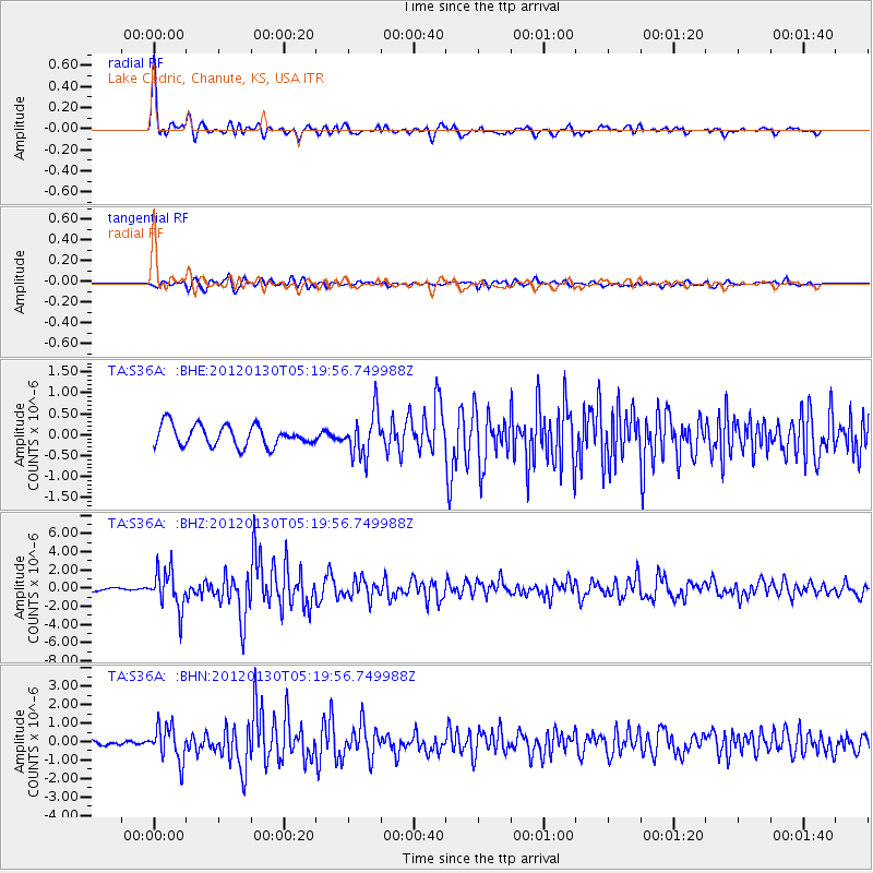
Signal To Noise
| Channel | StoN | STA | LTA |
| TA:S36A: :BHZ:20120130T05:19:56.749988Z | 8.928515 | 2.099138E-6 | 2.3510492E-7 |
| TA:S36A: :BHN:20120130T05:19:56.749988Z | 5.053166 | 9.2811064E-7 | 1.8366914E-7 |
| TA:S36A: :BHE:20120130T05:19:56.749988Z | 2.0778031 | 5.1213163E-7 | 2.4647747E-7 |
| Arrivals |
| Ps | 5.3 SECOND |
| PpPs | 16 SECOND |
| PsPs/PpSs | 21 SECOND |


