You are here: Home > Network List > TA - USArray Transportable Network (new EarthScope stations) Stations List
> Station S34A Willow Spring Farm, Andover, KS, USA > Earthquake Result Viewer
S34A Willow Spring Farm, Andover, KS, USA - Earthquake Result Viewer
| Earthquake location: |
Near Coast Of Peru |
| Earthquake latitude/longitude: |
-14.2/-75.6 |
| Earthquake time(UTC): |
2012/01/30 (030) 05:11:00 GMT |
| Earthquake Depth: |
43 km |
| Earthquake Magnitude: |
6.3 MB, 5.9 MS, 6.4 MW, 6.4 MW |
| Earthquake Catalog/Contributor: |
WHDF/NEIC |
|
| Network: |
TA USArray Transportable Network (new EarthScope stations) |
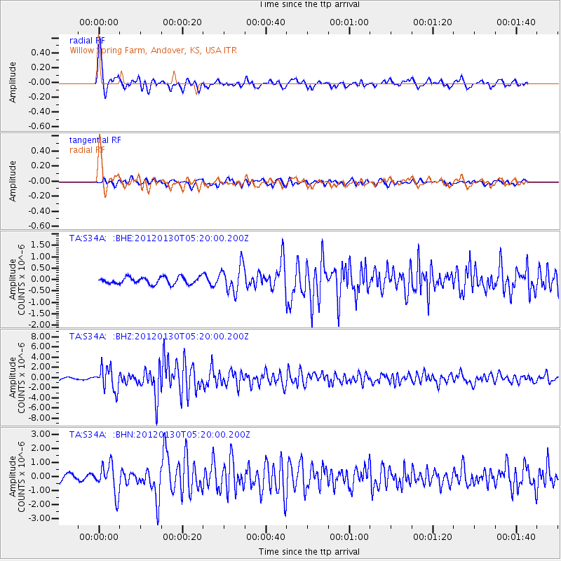
| Station: |
S34A Willow Spring Farm, Andover, KS, USA |
| Lat/Lon: |
37.70 N/97.11 W |
| Elevation: |
373 m |
|
| Distance: |
55.4 deg |
| Az: |
339.342 deg |
| Baz: |
154.442 deg |
| Ray Param: |
0.06472396 |
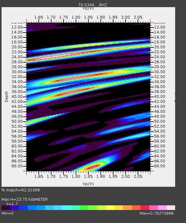
| Estimated Moho Depth: |
23.75 km |
| Estimated Crust Vp/Vs: |
1.70 |
| Assumed Crust Vp: |
6.483 km/s |
| Estimated Crust Vs: |
3.813 km/s |
| Estimated Crust Poisson's Ratio: |
0.24 |
|
| Radial Match: |
92.01099 % |
| Radial Bump: |
400 |
| Transverse Match: |
84.702126 % |
| Transverse Bump: |
400 |
| SOD ConfigId: |
436445 |
| Insert Time: |
2012-04-11 05:05:47.504 +0000 |
| GWidth: |
2.5 |
| Max Bumps: |
400 |
| Tol: |
0.001 |
|
Signal To Noise
| Channel | StoN | STA | LTA |
| TA:S34A: :BHZ:20120130T05:20:00.200Z | 11.162457 | 2.2054564E-6 | 1.9757803E-7 |
| TA:S34A: :BHN:20120130T05:20:00.200Z | 4.2737074 | 1.0674528E-6 | 2.4977206E-7 |
| TA:S34A: :BHE:20120130T05:20:00.200Z | 3.8657575 | 5.9260134E-7 | 1.5329502E-7 |
| Arrivals |
| Ps | 2.7 SECOND |
| PpPs | 9.4 SECOND |
| PsPs/PpSs | 12 SECOND |


