You are here: Home > Network List > TA - USArray Transportable Network (new EarthScope stations) Stations List
> Station Y36A Durant, OK, USA > Earthquake Result Viewer
Y36A Durant, OK, USA - Earthquake Result Viewer
| Earthquake location: |
Near Coast Of Peru |
| Earthquake latitude/longitude: |
-14.2/-75.6 |
| Earthquake time(UTC): |
2012/01/30 (030) 05:11:00 GMT |
| Earthquake Depth: |
43 km |
| Earthquake Magnitude: |
6.3 MB, 5.9 MS, 6.4 MW, 6.4 MW |
| Earthquake Catalog/Contributor: |
WHDF/NEIC |
|
| Network: |
TA USArray Transportable Network (new EarthScope stations) |
| Station: |
Y36A Durant, OK, USA |
| Lat/Lon: |
33.90 N/96.28 W |
| Elevation: |
186 m |
|
| Distance: |
51.7 deg |
| Az: |
338.049 deg |
| Baz: |
154.155 deg |
| Ray Param: |
0.06714808 |
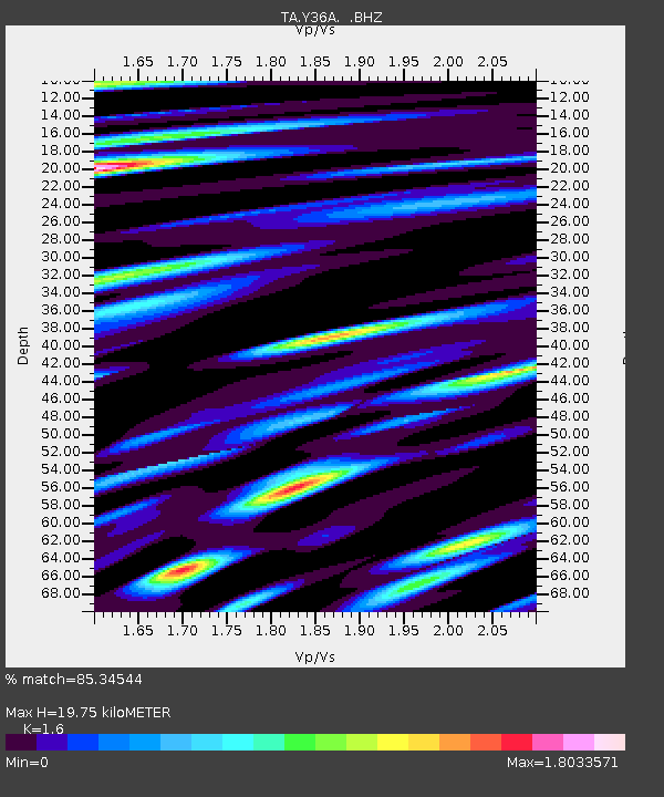
| Estimated Moho Depth: |
19.75 km |
| Estimated Crust Vp/Vs: |
1.60 |
| Assumed Crust Vp: |
6.38 km/s |
| Estimated Crust Vs: |
3.988 km/s |
| Estimated Crust Poisson's Ratio: |
0.18 |
|
| Radial Match: |
85.34544 % |
| Radial Bump: |
400 |
| Transverse Match: |
76.898 % |
| Transverse Bump: |
400 |
| SOD ConfigId: |
436445 |
| Insert Time: |
2012-04-11 05:07:12.460 +0000 |
| GWidth: |
2.5 |
| Max Bumps: |
400 |
| Tol: |
0.001 |
|

Signal To Noise
| Channel | StoN | STA | LTA |
| TA:Y36A: :BHZ:20120130T05:19:33.100024Z | 9.271719 | 1.7639708E-6 | 1.9025282E-7 |
| TA:Y36A: :BHN:20120130T05:19:33.100024Z | 5.182933 | 9.1540613E-7 | 1.7661932E-7 |
| TA:Y36A: :BHE:20120130T05:19:33.100024Z | 2.1283443 | 5.6572884E-7 | 2.6580702E-7 |
| Arrivals |
| Ps | 2.0 SECOND |
| PpPs | 7.6 SECOND |
| PsPs/PpSs | 9.5 SECOND |


