You are here: Home > Network List > TA - USArray Transportable Network (new EarthScope stations) Stations List
> Station N35A Tabor, IA, USA > Earthquake Result Viewer
N35A Tabor, IA, USA - Earthquake Result Viewer
| Earthquake location: |
Near Coast Of Peru |
| Earthquake latitude/longitude: |
-14.2/-75.6 |
| Earthquake time(UTC): |
2012/01/30 (030) 05:11:00 GMT |
| Earthquake Depth: |
43 km |
| Earthquake Magnitude: |
6.3 MB, 5.9 MS, 6.4 MW, 6.4 MW |
| Earthquake Catalog/Contributor: |
WHDF/NEIC |
|
| Network: |
TA USArray Transportable Network (new EarthScope stations) |
| Station: |
N35A Tabor, IA, USA |
| Lat/Lon: |
40.86 N/95.64 W |
| Elevation: |
353 m |
|
| Distance: |
57.8 deg |
| Az: |
342.143 deg |
| Baz: |
156.911 deg |
| Ray Param: |
0.0631647 |
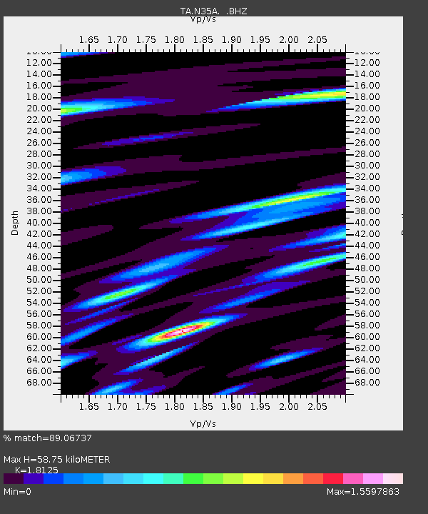
| Estimated Moho Depth: |
58.75 km |
| Estimated Crust Vp/Vs: |
1.81 |
| Assumed Crust Vp: |
6.498 km/s |
| Estimated Crust Vs: |
3.585 km/s |
| Estimated Crust Poisson's Ratio: |
0.28 |
|
| Radial Match: |
89.06737 % |
| Radial Bump: |
400 |
| Transverse Match: |
82.13966 % |
| Transverse Bump: |
400 |
| SOD ConfigId: |
436445 |
| Insert Time: |
2012-04-11 05:08:23.167 +0000 |
| GWidth: |
2.5 |
| Max Bumps: |
400 |
| Tol: |
0.001 |
|
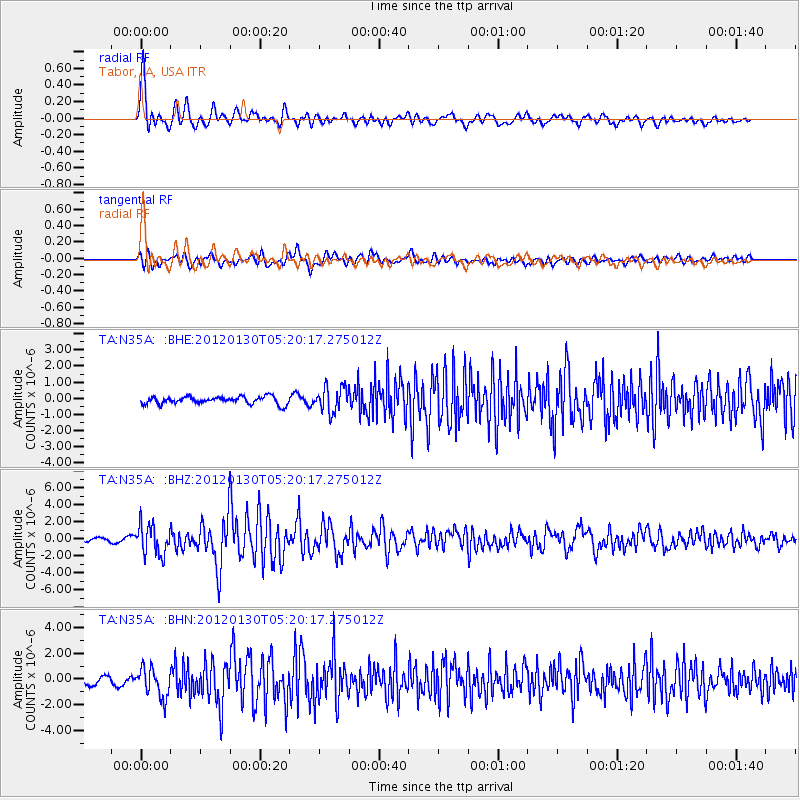
Signal To Noise
| Channel | StoN | STA | LTA |
| TA:N35A: :BHZ:20120130T05:20:17.275012Z | 7.101581 | 1.7380437E-6 | 2.447404E-7 |
| TA:N35A: :BHN:20120130T05:20:17.275012Z | 3.505325 | 1.1522794E-6 | 3.2872256E-7 |
| TA:N35A: :BHE:20120130T05:20:17.275012Z | 3.3813958 | 7.724758E-7 | 2.284488E-7 |
| Arrivals |
| Ps | 7.7 SECOND |
| PpPs | 24 SECOND |
| PsPs/PpSs | 32 SECOND |


