You are here: Home > Network List > TA - USArray Transportable Network (new EarthScope stations) Stations List
> Station M34A Aspy Farms, Fremont, NE, USA > Earthquake Result Viewer
M34A Aspy Farms, Fremont, NE, USA - Earthquake Result Viewer
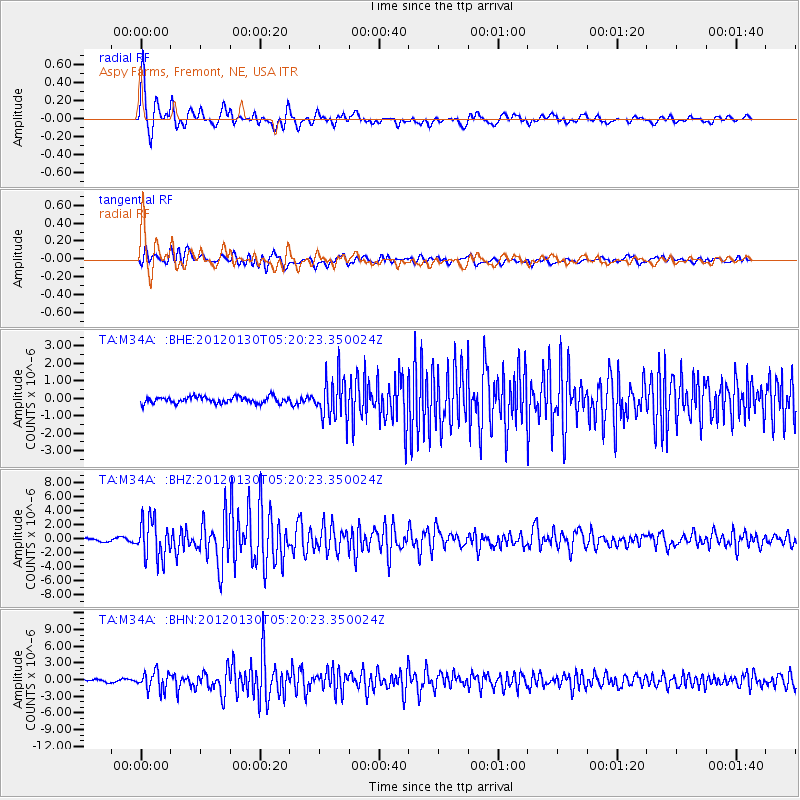
| Earthquake location: |
Near Coast Of Peru |
| Earthquake latitude/longitude: |
-14.2/-75.6 |
| Earthquake time(UTC): |
2012/01/30 (030) 05:11:00 GMT |
| Earthquake Depth: |
43 km |
| Earthquake Magnitude: |
6.3 MB, 5.9 MS, 6.4 MW, 6.4 MW |
| Earthquake Catalog/Contributor: |
WHDF/NEIC |
|
| Network: |
TA USArray Transportable Network (new EarthScope stations) |
| Station: |
M34A Aspy Farms, Fremont, NE, USA |
| Lat/Lon: |
41.50 N/96.58 W |
| Elevation: |
415 m |
|
| Distance: |
58.7 deg |
| Az: |
341.678 deg |
| Baz: |
156.049 deg |
| Ray Param: |
0.06259806 |
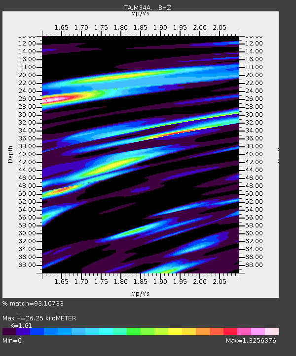
| Estimated Moho Depth: |
26.25 km |
| Estimated Crust Vp/Vs: |
1.61 |
| Assumed Crust Vp: |
6.498 km/s |
| Estimated Crust Vs: |
4.036 km/s |
| Estimated Crust Poisson's Ratio: |
0.19 |
|
| Radial Match: |
93.10733 % |
| Radial Bump: |
400 |
| Transverse Match: |
87.004776 % |
| Transverse Bump: |
400 |
| SOD ConfigId: |
436445 |
| Insert Time: |
2012-04-11 05:09:26.641 +0000 |
| GWidth: |
2.5 |
| Max Bumps: |
400 |
| Tol: |
0.001 |
|
Signal To Noise
| Channel | StoN | STA | LTA |
| TA:M34A: :BHZ:20120130T05:20:23.350024Z | 19.801891 | 2.7755489E-6 | 1.4016585E-7 |
| TA:M34A: :BHN:20120130T05:20:23.350024Z | 6.140463 | 1.6231681E-6 | 2.6433972E-7 |
| TA:M34A: :BHE:20120130T05:20:23.350024Z | 6.327159 | 1.1742646E-6 | 1.8559113E-7 |
| Arrivals |
| Ps | 2.6 SECOND |
| PpPs | 10.0 SECOND |
| PsPs/PpSs | 13 SECOND |


