You are here: Home > Network List > TA - USArray Transportable Network (new EarthScope stations) Stations List
> Station O03E Paynes Creek, CA, USA > Earthquake Result Viewer
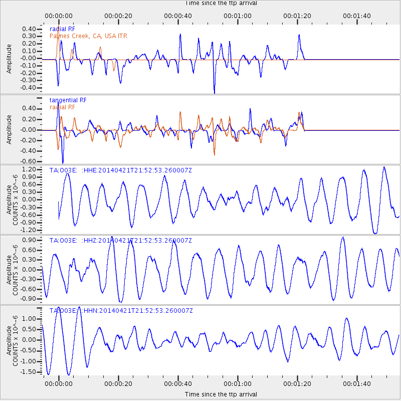
O03E Paynes Creek, CA, USA - Earthquake Result Viewer
*The percent match for this event was below the threshold and hence no stack was calculated.
| Earthquake location: |
Tonga Islands |
| Earthquake latitude/longitude: |
-20.3/-173.7 |
| Earthquake time(UTC): |
2014/04/21 (111) 21:41:32 GMT |
| Earthquake Depth: |
20 km |
| Earthquake Magnitude: |
5.2 MW |
| Earthquake Catalog/Contributor: |
ISC/ISC |
|
| Network: |
TA USArray Transportable Network (new EarthScope stations) |
| Station: |
O03E Paynes Creek, CA, USA |
| Lat/Lon: |
40.29 N/121.80 W |
| Elevation: |
967 m |
|
| Distance: |
77.2 deg |
| Az: |
38.084 deg |
| Baz: |
229.207 deg |
| Ray Param: |
$rayparam |
*The percent match for this event was below the threshold and hence was not used in the summary stack. |
|
| Radial Match: |
55.855762 % |
| Radial Bump: |
400 |
| Transverse Match: |
73.16405 % |
| Transverse Bump: |
400 |
| SOD ConfigId: |
3390531 |
| Insert Time: |
2019-04-11 14:10:25.275 +0000 |
| GWidth: |
2.5 |
| Max Bumps: |
400 |
| Tol: |
0.001 |
|
Signal To Noise
| Channel | StoN | STA | LTA |
| TA:O03E: :HHZ:20140421T21:52:53.260007Z | 1.0040543 | 3.568106E-7 | 3.5536985E-7 |
| TA:O03E: :HHN:20140421T21:52:53.260007Z | 2.7337055 | 1.1855338E-6 | 4.3367285E-7 |
| TA:O03E: :HHE:20140421T21:52:53.260007Z | 0.79596484 | 4.3630928E-7 | 5.4815143E-7 |
| Arrivals |
| Ps | |
| PpPs | |
| PsPs/PpSs | |


