You are here: Home > Network List > TA - USArray Transportable Network (new EarthScope stations) Stations List
> Station N33A J Bar K, Exeter, NE, USA > Earthquake Result Viewer
N33A J Bar K, Exeter, NE, USA - Earthquake Result Viewer
| Earthquake location: |
Near Coast Of Peru |
| Earthquake latitude/longitude: |
-14.2/-75.6 |
| Earthquake time(UTC): |
2012/01/30 (030) 05:11:00 GMT |
| Earthquake Depth: |
43 km |
| Earthquake Magnitude: |
6.3 MB, 5.9 MS, 6.4 MW, 6.4 MW |
| Earthquake Catalog/Contributor: |
WHDF/NEIC |
|
| Network: |
TA USArray Transportable Network (new EarthScope stations) |
| Station: |
N33A J Bar K, Exeter, NE, USA |
| Lat/Lon: |
40.74 N/97.45 W |
| Elevation: |
475 m |
|
| Distance: |
58.3 deg |
| Az: |
340.606 deg |
| Baz: |
154.921 deg |
| Ray Param: |
0.06287305 |
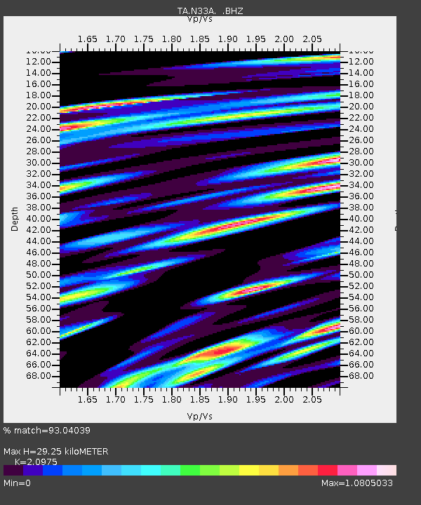
| Estimated Moho Depth: |
29.25 km |
| Estimated Crust Vp/Vs: |
2.10 |
| Assumed Crust Vp: |
6.498 km/s |
| Estimated Crust Vs: |
3.098 km/s |
| Estimated Crust Poisson's Ratio: |
0.35 |
|
| Radial Match: |
93.04039 % |
| Radial Bump: |
400 |
| Transverse Match: |
79.93005 % |
| Transverse Bump: |
400 |
| SOD ConfigId: |
436445 |
| Insert Time: |
2012-04-11 05:11:34.766 +0000 |
| GWidth: |
2.5 |
| Max Bumps: |
400 |
| Tol: |
0.001 |
|

Signal To Noise
| Channel | StoN | STA | LTA |
| TA:N33A: :BHZ:20120130T05:20:20.400012Z | 10.6085 | 2.2715394E-6 | 2.1412447E-7 |
| TA:N33A: :BHN:20120130T05:20:20.400012Z | 6.2748675 | 1.7317396E-6 | 2.7598028E-7 |
| TA:N33A: :BHE:20120130T05:20:20.400012Z | 3.4454699 | 1.1052699E-6 | 3.207893E-7 |
| Arrivals |
| Ps | 5.2 SECOND |
| PpPs | 13 SECOND |
| PsPs/PpSs | 19 SECOND |


