You are here: Home > Network List > TA - USArray Transportable Network (new EarthScope stations) Stations List
> Station L32A Elgin, NE, USA > Earthquake Result Viewer
L32A Elgin, NE, USA - Earthquake Result Viewer

| Earthquake location: |
Near Coast Of Peru |
| Earthquake latitude/longitude: |
-14.2/-75.6 |
| Earthquake time(UTC): |
2012/01/30 (030) 05:11:00 GMT |
| Earthquake Depth: |
43 km |
| Earthquake Magnitude: |
6.3 MB, 5.9 MS, 6.4 MW, 6.4 MW |
| Earthquake Catalog/Contributor: |
WHDF/NEIC |
|
| Network: |
TA USArray Transportable Network (new EarthScope stations) |
| Station: |
L32A Elgin, NE, USA |
| Lat/Lon: |
42.00 N/98.01 W |
| Elevation: |
586 m |
|
| Distance: |
59.6 deg |
| Az: |
340.792 deg |
| Baz: |
154.65 deg |
| Ray Param: |
0.062006123 |
| Estimated Moho Depth: |
10.0 km |
| Estimated Crust Vp/Vs: |
1.60 |
| Assumed Crust Vp: |
6.53 km/s |
| Estimated Crust Vs: |
4.082 km/s |
| Estimated Crust Poisson's Ratio: |
0.18 |
|
| Radial Match: |
88.88355 % |
| Radial Bump: |
400 |
| Transverse Match: |
82.66713 % |
| Transverse Bump: |
400 |
| SOD ConfigId: |
436445 |
| Insert Time: |
2012-04-11 05:12:38.242 +0000 |
| GWidth: |
2.5 |
| Max Bumps: |
400 |
| Tol: |
0.001 |
|
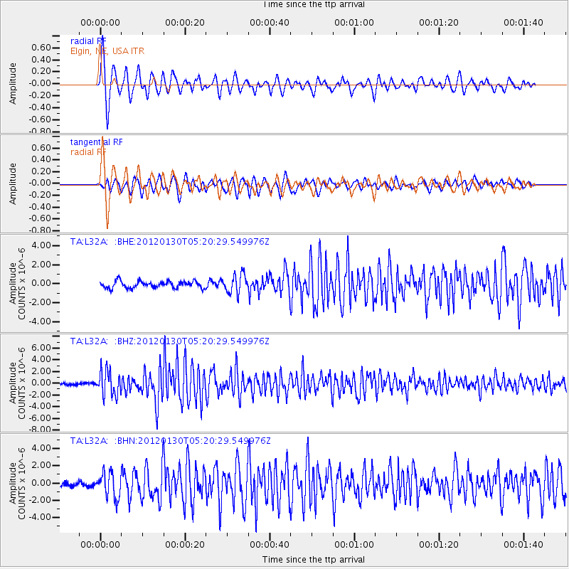
Signal To Noise
| Channel | StoN | STA | LTA |
| TA:L32A: :BHZ:20120130T05:20:29.549976Z | 8.313674 | 2.1410315E-6 | 2.5753133E-7 |
| TA:L32A: :BHN:20120130T05:20:29.549976Z | 4.15713 | 1.4809629E-6 | 3.562465E-7 |
| TA:L32A: :BHE:20120130T05:20:29.549976Z | 2.7737794 | 9.907769E-7 | 3.5719384E-7 |
| Arrivals |
| Ps | 1.0 SECOND |
| PpPs | 3.8 SECOND |
| PsPs/PpSs | 4.7 SECOND |


