You are here: Home > Network List > TA - USArray Transportable Network (new EarthScope stations) Stations List
> Station J35A Milford, IA, USA > Earthquake Result Viewer
J35A Milford, IA, USA - Earthquake Result Viewer

| Earthquake location: |
Near Coast Of Peru |
| Earthquake latitude/longitude: |
-14.2/-75.6 |
| Earthquake time(UTC): |
2012/01/30 (030) 05:11:00 GMT |
| Earthquake Depth: |
43 km |
| Earthquake Magnitude: |
6.3 MB, 5.9 MS, 6.4 MW, 6.4 MW |
| Earthquake Catalog/Contributor: |
WHDF/NEIC |
|
| Network: |
TA USArray Transportable Network (new EarthScope stations) |
| Station: |
J35A Milford, IA, USA |
| Lat/Lon: |
43.37 N/95.21 W |
| Elevation: |
457 m |
|
| Distance: |
60.0 deg |
| Az: |
343.613 deg |
| Baz: |
157.961 deg |
| Ray Param: |
0.06173547 |
| Estimated Moho Depth: |
11.5 km |
| Estimated Crust Vp/Vs: |
1.99 |
| Assumed Crust Vp: |
6.53 km/s |
| Estimated Crust Vs: |
3.29 km/s |
| Estimated Crust Poisson's Ratio: |
0.33 |
|
| Radial Match: |
94.206375 % |
| Radial Bump: |
400 |
| Transverse Match: |
85.65592 % |
| Transverse Bump: |
400 |
| SOD ConfigId: |
436445 |
| Insert Time: |
2012-04-11 05:13:57.376 +0000 |
| GWidth: |
2.5 |
| Max Bumps: |
400 |
| Tol: |
0.001 |
|
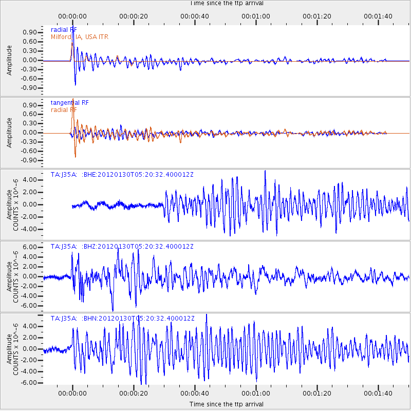
Signal To Noise
| Channel | StoN | STA | LTA |
| TA:J35A: :BHZ:20120130T05:20:32.400012Z | 7.9509096 | 2.4548583E-6 | 3.087519E-7 |
| TA:J35A: :BHN:20120130T05:20:32.400012Z | 6.6410875 | 2.27217E-6 | 3.4213824E-7 |
| TA:J35A: :BHE:20120130T05:20:32.400012Z | 4.3877673 | 1.3367736E-6 | 3.0465918E-7 |
| Arrivals |
| Ps | 1.8 SECOND |
| PpPs | 5.0 SECOND |
| PsPs/PpSs | 6.8 SECOND |


