You are here: Home > Network List > TA - USArray Transportable Network (new EarthScope stations) Stations List
> Station C31A Landman Farms, Northwood, ND, USA > Earthquake Result Viewer
C31A Landman Farms, Northwood, ND, USA - Earthquake Result Viewer
| Earthquake location: |
Near Coast Of Peru |
| Earthquake latitude/longitude: |
-14.2/-75.6 |
| Earthquake time(UTC): |
2012/01/30 (030) 05:11:00 GMT |
| Earthquake Depth: |
43 km |
| Earthquake Magnitude: |
6.3 MB, 5.9 MS, 6.4 MW, 6.4 MW |
| Earthquake Catalog/Contributor: |
WHDF/NEIC |
|
| Network: |
TA USArray Transportable Network (new EarthScope stations) |
| Station: |
C31A Landman Farms, Northwood, ND, USA |
| Lat/Lon: |
47.79 N/97.73 W |
| Elevation: |
384 m |
|
| Distance: |
64.8 deg |
| Az: |
343.714 deg |
| Baz: |
156.208 deg |
| Ray Param: |
0.05863185 |
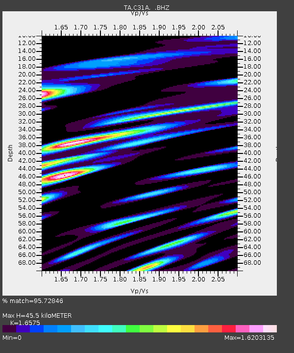
| Estimated Moho Depth: |
45.5 km |
| Estimated Crust Vp/Vs: |
1.66 |
| Assumed Crust Vp: |
6.498 km/s |
| Estimated Crust Vs: |
3.92 km/s |
| Estimated Crust Poisson's Ratio: |
0.21 |
|
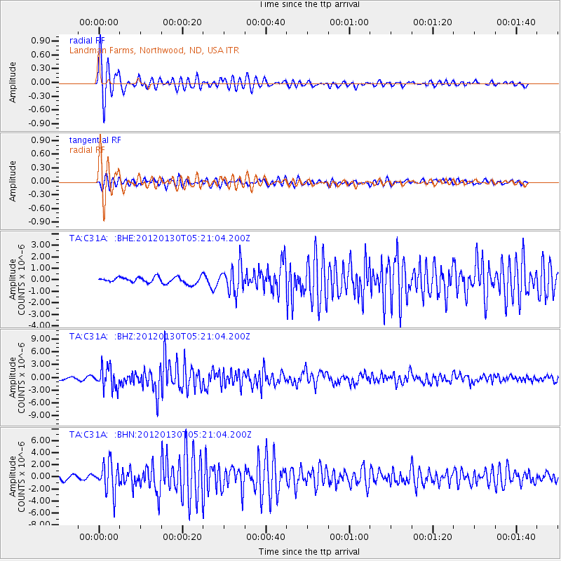
| Radial Match: |
95.72846 % |
| Radial Bump: |
318 |
| Transverse Match: |
83.482475 % |
| Transverse Bump: |
400 |
| SOD ConfigId: |
436445 |
| Insert Time: |
2012-04-11 05:16:04.931 +0000 |
| GWidth: |
2.5 |
| Max Bumps: |
400 |
| Tol: |
0.001 |
|
Signal To Noise
| Channel | StoN | STA | LTA |
| TA:C31A: :BHZ:20120130T05:21:04.200Z | 11.459851 | 2.498016E-6 | 2.179798E-7 |
| TA:C31A: :BHN:20120130T05:21:04.200Z | 7.064453 | 2.4647707E-6 | 3.488976E-7 |
| TA:C31A: :BHE:20120130T05:21:04.200Z | 4.383903 | 1.181362E-6 | 2.6947723E-7 |
| Arrivals |
| Ps | 4.8 SECOND |
| PpPs | 18 SECOND |
| PsPs/PpSs | 23 SECOND |


