You are here: Home > Network List > TA - USArray Transportable Network (new EarthScope stations) Stations List
> Station E35A Pequot Lakes, MN, USA > Earthquake Result Viewer
E35A Pequot Lakes, MN, USA - Earthquake Result Viewer
| Earthquake location: |
Near Coast Of Peru |
| Earthquake latitude/longitude: |
-14.2/-75.6 |
| Earthquake time(UTC): |
2012/01/30 (030) 05:11:00 GMT |
| Earthquake Depth: |
43 km |
| Earthquake Magnitude: |
6.3 MB, 5.9 MS, 6.4 MW, 6.4 MW |
| Earthquake Catalog/Contributor: |
WHDF/NEIC |
|
| Network: |
TA USArray Transportable Network (new EarthScope stations) |
| Station: |
E35A Pequot Lakes, MN, USA |
| Lat/Lon: |
46.56 N/94.40 W |
| Elevation: |
409 m |
|
| Distance: |
62.8 deg |
| Az: |
345.539 deg |
| Baz: |
159.45 deg |
| Ray Param: |
0.05993071 |
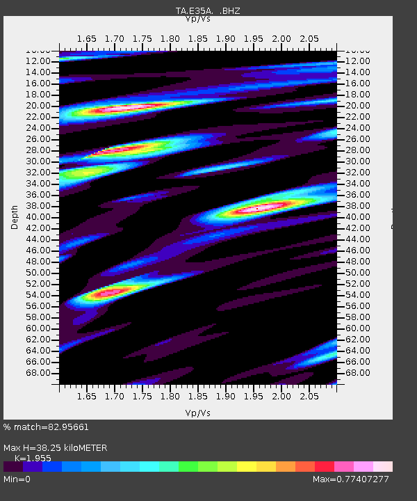
| Estimated Moho Depth: |
38.25 km |
| Estimated Crust Vp/Vs: |
1.96 |
| Assumed Crust Vp: |
6.419 km/s |
| Estimated Crust Vs: |
3.283 km/s |
| Estimated Crust Poisson's Ratio: |
0.32 |
|
| Radial Match: |
82.95661 % |
| Radial Bump: |
400 |
| Transverse Match: |
81.91951 % |
| Transverse Bump: |
400 |
| SOD ConfigId: |
436445 |
| Insert Time: |
2012-04-11 05:16:17.248 +0000 |
| GWidth: |
2.5 |
| Max Bumps: |
400 |
| Tol: |
0.001 |
|
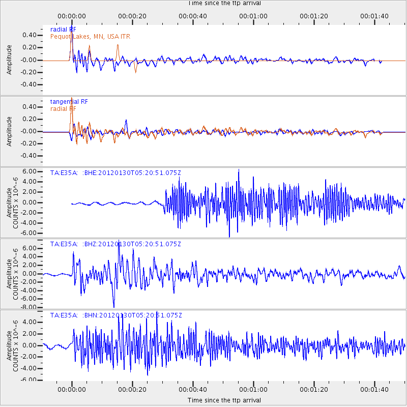
Signal To Noise
| Channel | StoN | STA | LTA |
| TA:E35A: :BHZ:20120130T05:20:51.075Z | 14.910953 | 2.474214E-6 | 1.6593265E-7 |
| TA:E35A: :BHN:20120130T05:20:51.075Z | 5.7272415 | 1.5444265E-6 | 2.6966325E-7 |
| TA:E35A: :BHE:20120130T05:20:51.075Z | 8.884072 | 1.5402952E-6 | 1.7337716E-7 |
| Arrivals |
| Ps | 5.9 SECOND |
| PpPs | 17 SECOND |
| PsPs/PpSs | 23 SECOND |


