You are here: Home > Network List > TA - USArray Transportable Network (new EarthScope stations) Stations List
> Station G34A Benson, MN, USA > Earthquake Result Viewer
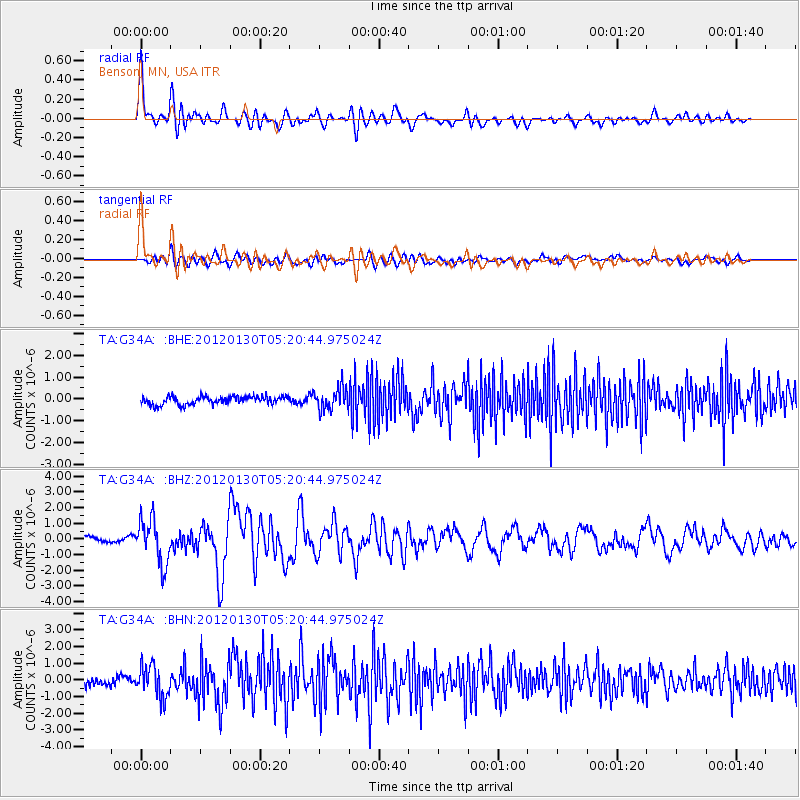
G34A Benson, MN, USA - Earthquake Result Viewer

| Earthquake location: |
Near Coast Of Peru |
| Earthquake latitude/longitude: |
-14.2/-75.6 |
| Earthquake time(UTC): |
2012/01/30 (030) 05:11:00 GMT |
| Earthquake Depth: |
43 km |
| Earthquake Magnitude: |
6.3 MB, 5.9 MS, 6.4 MW, 6.4 MW |
| Earthquake Catalog/Contributor: |
WHDF/NEIC |
|
| Network: |
TA USArray Transportable Network (new EarthScope stations) |
| Station: |
G34A Benson, MN, USA |
| Lat/Lon: |
45.24 N/95.64 W |
| Elevation: |
316 m |
|
| Distance: |
61.8 deg |
| Az: |
344.092 deg |
| Baz: |
157.894 deg |
| Ray Param: |
0.060528707 |
| Estimated Moho Depth: |
30.5 km |
| Estimated Crust Vp/Vs: |
2.05 |
| Assumed Crust Vp: |
6.571 km/s |
| Estimated Crust Vs: |
3.213 km/s |
| Estimated Crust Poisson's Ratio: |
0.34 |
|
| Radial Match: |
83.54521 % |
| Radial Bump: |
400 |
| Transverse Match: |
64.07594 % |
| Transverse Bump: |
400 |
| SOD ConfigId: |
436445 |
| Insert Time: |
2012-04-11 05:18:24.958 +0000 |
| GWidth: |
2.5 |
| Max Bumps: |
400 |
| Tol: |
0.001 |
|
Signal To Noise
| Channel | StoN | STA | LTA |
| TA:G34A: :BHZ:20120130T05:20:44.975024Z | 9.09959 | 1.4371856E-6 | 1.579396E-7 |
| TA:G34A: :BHN:20120130T05:20:44.975024Z | 3.7219124 | 9.486054E-7 | 2.5487043E-7 |
| TA:G34A: :BHE:20120130T05:20:44.975024Z | 2.793392 | 5.119238E-7 | 1.8326244E-7 |
| Arrivals |
| Ps | 5.1 SECOND |
| PpPs | 14 SECOND |
| PsPs/PpSs | 19 SECOND |


