You are here: Home > Network List > TA - USArray Transportable Network (new EarthScope stations) Stations List
> Station C36A Pine Crest Fram, Angora, MN, USA > Earthquake Result Viewer
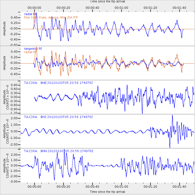
C36A Pine Crest Fram, Angora, MN, USA - Earthquake Result Viewer
*The percent match for this event was below the threshold and hence no stack was calculated.
| Earthquake location: |
Near Coast Of Peru |
| Earthquake latitude/longitude: |
-14.2/-75.6 |
| Earthquake time(UTC): |
2012/01/30 (030) 05:11:00 GMT |
| Earthquake Depth: |
43 km |
| Earthquake Magnitude: |
6.3 MB, 5.9 MS, 6.4 MW, 6.4 MW |
| Earthquake Catalog/Contributor: |
WHDF/NEIC |
|
| Network: |
TA USArray Transportable Network (new EarthScope stations) |
| Station: |
C36A Pine Crest Fram, Angora, MN, USA |
| Lat/Lon: |
47.76 N/92.84 W |
| Elevation: |
410 m |
|
| Distance: |
63.5 deg |
| Az: |
347.119 deg |
| Baz: |
161.309 deg |
| Ray Param: |
$rayparam |
*The percent match for this event was below the threshold and hence was not used in the summary stack. |
|
| Radial Match: |
35.20162 % |
| Radial Bump: |
368 |
| Transverse Match: |
31.20848 % |
| Transverse Bump: |
395 |
| SOD ConfigId: |
436445 |
| Insert Time: |
2012-04-11 05:18:27.468 +0000 |
| GWidth: |
2.5 |
| Max Bumps: |
400 |
| Tol: |
0.001 |
|
Signal To Noise
| Channel | StoN | STA | LTA |
| TA:C36A: :BHZ:20120130T05:20:56.174976Z | 1.1408877 | 1.9694941E-7 | 1.7262822E-7 |
| TA:C36A: :BHN:20120130T05:20:56.174976Z | 4.9606514 | 1.1241758E-6 | 2.2661858E-7 |
| TA:C36A: :BHE:20120130T05:20:56.174976Z | 2.1474257 | 2.8435966E-7 | 1.3241886E-7 |
| Arrivals |
| Ps | |
| PpPs | |
| PsPs/PpSs | |


