You are here: Home > Network List > TA - USArray Transportable Network (new EarthScope stations) Stations List
> Station Q38A Cook's Store, Concordia, MO, USA > Earthquake Result Viewer
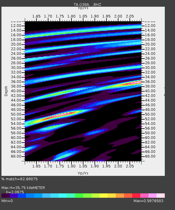
Q38A Cook's Store, Concordia, MO, USA - Earthquake Result Viewer
| Earthquake location: |
Near Coast Of Peru |
| Earthquake latitude/longitude: |
-14.2/-75.6 |
| Earthquake time(UTC): |
2012/01/30 (030) 05:11:00 GMT |
| Earthquake Depth: |
43 km |
| Earthquake Magnitude: |
6.3 MB, 5.9 MS, 6.4 MW, 6.4 MW |
| Earthquake Catalog/Contributor: |
WHDF/NEIC |
|
| Network: |
TA USArray Transportable Network (new EarthScope stations) |
| Station: |
Q38A Cook's Store, Concordia, MO, USA |
| Lat/Lon: |
38.96 N/93.62 W |
| Elevation: |
228 m |
|
| Distance: |
55.5 deg |
| Az: |
343.01 deg |
| Baz: |
158.682 deg |
| Ray Param: |
0.06468416 |
| Estimated Moho Depth: |
35.75 km |
| Estimated Crust Vp/Vs: |
2.10 |
| Assumed Crust Vp: |
6.498 km/s |
| Estimated Crust Vs: |
3.098 km/s |
| Estimated Crust Poisson's Ratio: |
0.35 |
|
| Radial Match: |
92.69875 % |
| Radial Bump: |
363 |
| Transverse Match: |
76.81067 % |
| Transverse Bump: |
400 |
| SOD ConfigId: |
436445 |
| Insert Time: |
2012-04-11 05:22:51.876 +0000 |
| GWidth: |
2.5 |
| Max Bumps: |
400 |
| Tol: |
0.001 |
|

Signal To Noise
| Channel | StoN | STA | LTA |
| TA:Q38A: :BHZ:20120130T05:20:00.650012Z | 17.35935 | 2.8823454E-6 | 1.6603992E-7 |
| TA:Q38A: :BHN:20120130T05:20:00.650012Z | 7.2827196 | 1.4231663E-6 | 1.9541687E-7 |
| TA:Q38A: :BHE:20120130T05:20:00.650012Z | 2.6196795 | 4.7412425E-7 | 1.809856E-7 |
| Arrivals |
| Ps | 6.3 SECOND |
| PpPs | 16 SECOND |
| PsPs/PpSs | 23 SECOND |


