You are here: Home > Network List > TA - USArray Transportable Network (new EarthScope stations) Stations List
> Station O40A La Belle, MO, USA > Earthquake Result Viewer
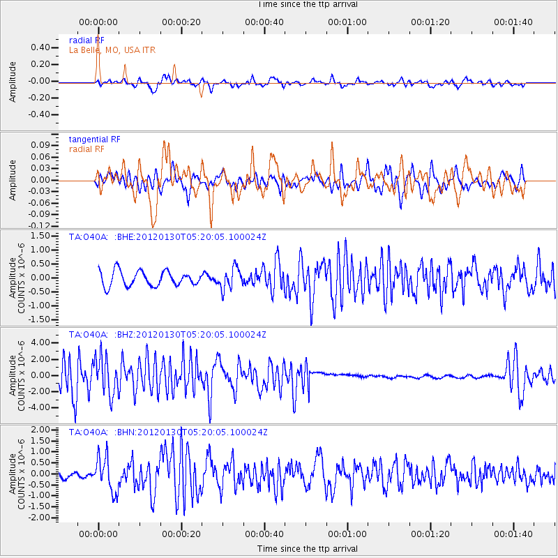
O40A La Belle, MO, USA - Earthquake Result Viewer
*The percent match for this event was below the threshold and hence no stack was calculated.
| Earthquake location: |
Near Coast Of Peru |
| Earthquake latitude/longitude: |
-14.2/-75.6 |
| Earthquake time(UTC): |
2012/01/30 (030) 05:11:00 GMT |
| Earthquake Depth: |
43 km |
| Earthquake Magnitude: |
6.3 MB, 5.9 MS, 6.4 MW, 6.4 MW |
| Earthquake Catalog/Contributor: |
WHDF/NEIC |
|
| Network: |
TA USArray Transportable Network (new EarthScope stations) |
| Station: |
O40A La Belle, MO, USA |
| Lat/Lon: |
40.12 N/91.87 W |
| Elevation: |
206 m |
|
| Distance: |
56.1 deg |
| Az: |
345.025 deg |
| Baz: |
160.921 deg |
| Ray Param: |
$rayparam |
*The percent match for this event was below the threshold and hence was not used in the summary stack. |
|
| Radial Match: |
56.015133 % |
| Radial Bump: |
400 |
| Transverse Match: |
60.822517 % |
| Transverse Bump: |
400 |
| SOD ConfigId: |
436445 |
| Insert Time: |
2012-04-11 05:23:34.378 +0000 |
| GWidth: |
2.5 |
| Max Bumps: |
400 |
| Tol: |
0.001 |
|
Signal To Noise
| Channel | StoN | STA | LTA |
| TA:O40A: :BHZ:20120130T05:20:05.100024Z | 1.1863989 | 2.314536E-6 | 1.950892E-6 |
| TA:O40A: :BHN:20120130T05:20:05.100024Z | 4.7114925 | 8.1386924E-7 | 1.7274128E-7 |
| TA:O40A: :BHE:20120130T05:20:05.100024Z | 1.4444879 | 3.8394538E-7 | 2.6580034E-7 |
| Arrivals |
| Ps | |
| PpPs | |
| PsPs/PpSs | |


