You are here: Home > Network List > TA - USArray Transportable Network (new EarthScope stations) Stations List
> Station T39A Clever, MO, USA > Earthquake Result Viewer
T39A Clever, MO, USA - Earthquake Result Viewer
| Earthquake location: |
Near Coast Of Peru |
| Earthquake latitude/longitude: |
-14.2/-75.6 |
| Earthquake time(UTC): |
2012/01/30 (030) 05:11:00 GMT |
| Earthquake Depth: |
43 km |
| Earthquake Magnitude: |
6.3 MB, 5.9 MS, 6.4 MW, 6.4 MW |
| Earthquake Catalog/Contributor: |
WHDF/NEIC |
|
| Network: |
TA USArray Transportable Network (new EarthScope stations) |
| Station: |
T39A Clever, MO, USA |
| Lat/Lon: |
37.02 N/93.38 W |
| Elevation: |
366 m |
|
| Distance: |
53.6 deg |
| Az: |
342.36 deg |
| Baz: |
158.452 deg |
| Ray Param: |
0.0658979 |
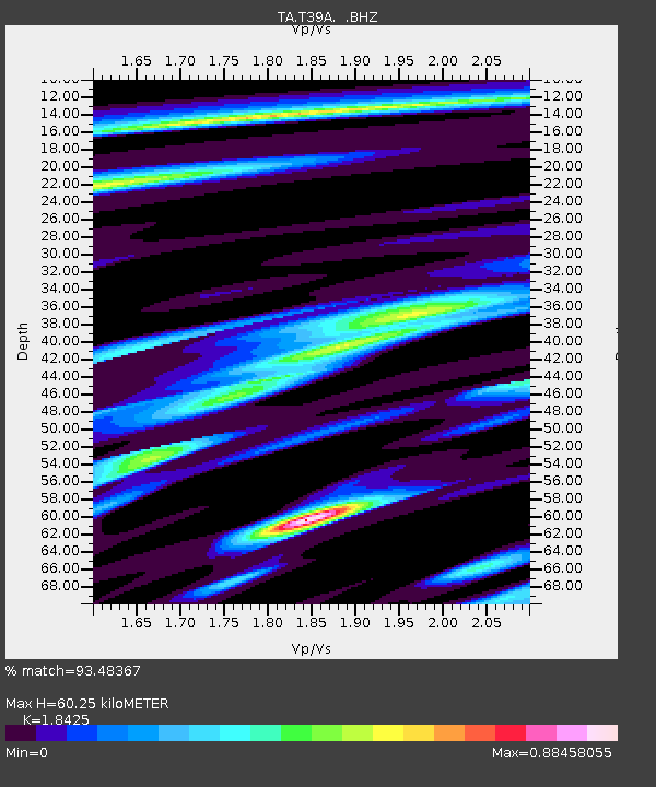
| Estimated Moho Depth: |
60.25 km |
| Estimated Crust Vp/Vs: |
1.84 |
| Assumed Crust Vp: |
6.53 km/s |
| Estimated Crust Vs: |
3.544 km/s |
| Estimated Crust Poisson's Ratio: |
0.29 |
|
| Radial Match: |
93.48367 % |
| Radial Bump: |
366 |
| Transverse Match: |
75.68527 % |
| Transverse Bump: |
400 |
| SOD ConfigId: |
436445 |
| Insert Time: |
2012-04-11 05:24:00.546 +0000 |
| GWidth: |
2.5 |
| Max Bumps: |
400 |
| Tol: |
0.001 |
|

Signal To Noise
| Channel | StoN | STA | LTA |
| TA:T39A: :BHZ:20120130T05:19:47.124988Z | 9.163436 | 1.4712218E-6 | 1.6055353E-7 |
| TA:T39A: :BHN:20120130T05:19:47.124988Z | 6.892799 | 7.52207E-7 | 1.09129395E-7 |
| TA:T39A: :BHE:20120130T05:19:47.124988Z | 3.8990726 | 3.6529835E-7 | 9.368852E-8 |
| Arrivals |
| Ps | 8.2 SECOND |
| PpPs | 25 SECOND |
| PsPs/PpSs | 33 SECOND |


