You are here: Home > Network List > TA - USArray Transportable Network (new EarthScope stations) Stations List
> Station X40A Basin Creek Farm, Marlvern, AR, USA > Earthquake Result Viewer
X40A Basin Creek Farm, Marlvern, AR, USA - Earthquake Result Viewer
| Earthquake location: |
Near Coast Of Peru |
| Earthquake latitude/longitude: |
-14.2/-75.6 |
| Earthquake time(UTC): |
2012/01/30 (030) 05:11:00 GMT |
| Earthquake Depth: |
43 km |
| Earthquake Magnitude: |
6.3 MB, 5.9 MS, 6.4 MW, 6.4 MW |
| Earthquake Catalog/Contributor: |
WHDF/NEIC |
|
| Network: |
TA USArray Transportable Network (new EarthScope stations) |
| Station: |
X40A Basin Creek Farm, Marlvern, AR, USA |
| Lat/Lon: |
34.49 N/92.83 W |
| Elevation: |
158 m |
|
| Distance: |
51.1 deg |
| Az: |
341.702 deg |
| Baz: |
158.366 deg |
| Ray Param: |
0.067545734 |
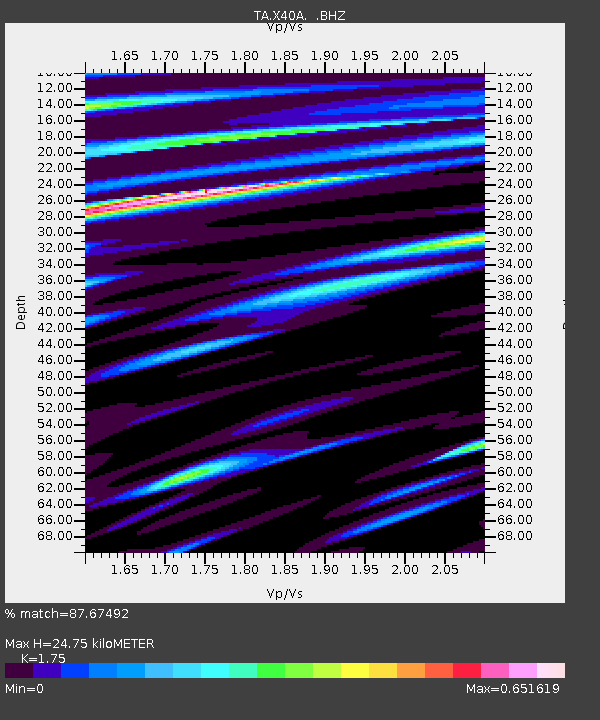
| Estimated Moho Depth: |
24.75 km |
| Estimated Crust Vp/Vs: |
1.75 |
| Assumed Crust Vp: |
6.498 km/s |
| Estimated Crust Vs: |
3.713 km/s |
| Estimated Crust Poisson's Ratio: |
0.26 |
|
| Radial Match: |
87.67492 % |
| Radial Bump: |
400 |
| Transverse Match: |
77.37234 % |
| Transverse Bump: |
400 |
| SOD ConfigId: |
436445 |
| Insert Time: |
2012-04-11 05:24:14.680 +0000 |
| GWidth: |
2.5 |
| Max Bumps: |
400 |
| Tol: |
0.001 |
|

Signal To Noise
| Channel | StoN | STA | LTA |
| TA:X40A: :BHZ:20120130T05:19:28.499988Z | 13.394161 | 1.6291261E-6 | 1.2162957E-7 |
| TA:X40A: :BHN:20120130T05:19:28.499988Z | 4.4197426 | 4.7135202E-7 | 1.06646944E-7 |
| TA:X40A: :BHE:20120130T05:19:28.499988Z | 2.3638716 | 3.4890067E-7 | 1.4759713E-7 |
| Arrivals |
| Ps | 3.0 SECOND |
| PpPs | 9.9 SECOND |
| PsPs/PpSs | 13 SECOND |


