You are here: Home > Network List > TA - USArray Transportable Network (new EarthScope stations) Stations List
> Station 141A Papa Simpson, Farm, Arcadia, LA, USA > Earthquake Result Viewer
141A Papa Simpson, Farm, Arcadia, LA, USA - Earthquake Result Viewer
| Earthquake location: |
Near Coast Of Peru |
| Earthquake latitude/longitude: |
-14.2/-75.6 |
| Earthquake time(UTC): |
2012/01/30 (030) 05:11:00 GMT |
| Earthquake Depth: |
43 km |
| Earthquake Magnitude: |
6.3 MB, 5.9 MS, 6.4 MW, 6.4 MW |
| Earthquake Catalog/Contributor: |
WHDF/NEIC |
|
| Network: |
TA USArray Transportable Network (new EarthScope stations) |
| Station: |
141A Papa Simpson, Farm, Arcadia, LA, USA |
| Lat/Lon: |
32.60 N/92.90 W |
| Elevation: |
91 m |
|
| Distance: |
49.4 deg |
| Az: |
340.717 deg |
| Baz: |
157.697 deg |
| Ray Param: |
0.06865356 |
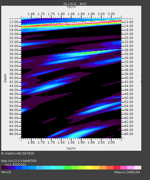
| Estimated Moho Depth: |
12.0 km |
| Estimated Crust Vp/Vs: |
1.92 |
| Assumed Crust Vp: |
6.245 km/s |
| Estimated Crust Vs: |
3.253 km/s |
| Estimated Crust Poisson's Ratio: |
0.31 |
|
| Radial Match: |
88.067825 % |
| Radial Bump: |
400 |
| Transverse Match: |
88.546616 % |
| Transverse Bump: |
400 |
| SOD ConfigId: |
436445 |
| Insert Time: |
2012-04-11 05:25:34.951 +0000 |
| GWidth: |
2.5 |
| Max Bumps: |
400 |
| Tol: |
0.001 |
|
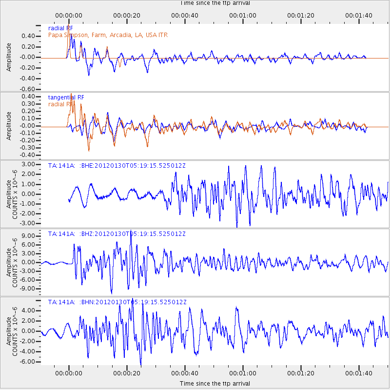
Signal To Noise
| Channel | StoN | STA | LTA |
| TA:141A: :BHZ:20120130T05:19:15.525012Z | 14.783339 | 3.614371E-6 | 2.4448948E-7 |
| TA:141A: :BHN:20120130T05:19:15.525012Z | 3.1119077 | 1.2312646E-6 | 3.956623E-7 |
| TA:141A: :BHE:20120130T05:19:15.525012Z | 1.0290226 | 5.3111637E-7 | 5.1613677E-7 |
| Arrivals |
| Ps | 1.9 SECOND |
| PpPs | 5.3 SECOND |
| PsPs/PpSs | 7.2 SECOND |


