You are here: Home > Network List > TA - USArray Transportable Network (new EarthScope stations) Stations List
> Station 147A Livingston, AL, USA > Earthquake Result Viewer
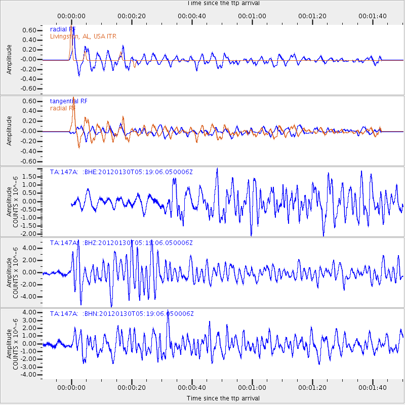
147A Livingston, AL, USA - Earthquake Result Viewer
*The percent match for this event was below the threshold and hence no stack was calculated.
| Earthquake location: |
Near Coast Of Peru |
| Earthquake latitude/longitude: |
-14.2/-75.6 |
| Earthquake time(UTC): |
2012/01/30 (030) 05:11:00 GMT |
| Earthquake Depth: |
43 km |
| Earthquake Magnitude: |
6.3 MB, 5.9 MS, 6.4 MW, 6.4 MW |
| Earthquake Catalog/Contributor: |
WHDF/NEIC |
|
| Network: |
TA USArray Transportable Network (new EarthScope stations) |
| Station: |
147A Livingston, AL, USA |
| Lat/Lon: |
32.67 N/88.27 W |
| Elevation: |
57 m |
|
| Distance: |
48.1 deg |
| Az: |
345.653 deg |
| Baz: |
163.442 deg |
| Ray Param: |
$rayparam |
*The percent match for this event was below the threshold and hence was not used in the summary stack. |
|
| Radial Match: |
78.79683 % |
| Radial Bump: |
400 |
| Transverse Match: |
71.76154 % |
| Transverse Bump: |
400 |
| SOD ConfigId: |
436445 |
| Insert Time: |
2012-04-11 05:29:04.574 +0000 |
| GWidth: |
2.5 |
| Max Bumps: |
400 |
| Tol: |
0.001 |
|
Signal To Noise
| Channel | StoN | STA | LTA |
| TA:147A: :BHZ:20120130T05:19:06.050006Z | 14.010397 | 2.6255627E-6 | 1.8740101E-7 |
| TA:147A: :BHN:20120130T05:19:06.050006Z | 5.4049344 | 1.2605941E-6 | 2.3323024E-7 |
| TA:147A: :BHE:20120130T05:19:06.050006Z | 2.254497 | 6.9845385E-7 | 3.0980473E-7 |
| Arrivals |
| Ps | |
| PpPs | |
| PsPs/PpSs | |


