You are here: Home > Network List > TA - USArray Transportable Network (new EarthScope stations) Stations List
> Station TPFO Pinon Flats, CA, USA > Earthquake Result Viewer
TPFO Pinon Flats, CA, USA - Earthquake Result Viewer
| Earthquake location: |
Near Coast Of Peru |
| Earthquake latitude/longitude: |
-14.2/-75.6 |
| Earthquake time(UTC): |
2012/01/30 (030) 05:11:00 GMT |
| Earthquake Depth: |
43 km |
| Earthquake Magnitude: |
6.3 MB, 5.9 MS, 6.4 MW, 6.4 MW |
| Earthquake Catalog/Contributor: |
WHDF/NEIC |
|
| Network: |
TA USArray Transportable Network (new EarthScope stations) |
| Station: |
TPFO Pinon Flats, CA, USA |
| Lat/Lon: |
33.61 N/116.45 W |
| Elevation: |
1275 m |
|
| Distance: |
61.4 deg |
| Az: |
321.587 deg |
| Baz: |
133.769 deg |
| Ray Param: |
0.060809672 |
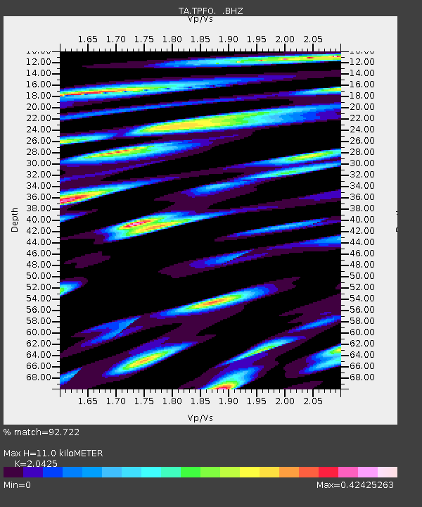
| Estimated Moho Depth: |
11.0 km |
| Estimated Crust Vp/Vs: |
2.04 |
| Assumed Crust Vp: |
6.264 km/s |
| Estimated Crust Vs: |
3.067 km/s |
| Estimated Crust Poisson's Ratio: |
0.34 |
|
| Radial Match: |
92.722 % |
| Radial Bump: |
400 |
| Transverse Match: |
72.62421 % |
| Transverse Bump: |
400 |
| SOD ConfigId: |
436445 |
| Insert Time: |
2012-04-11 05:30:21.380 +0000 |
| GWidth: |
2.5 |
| Max Bumps: |
400 |
| Tol: |
0.001 |
|
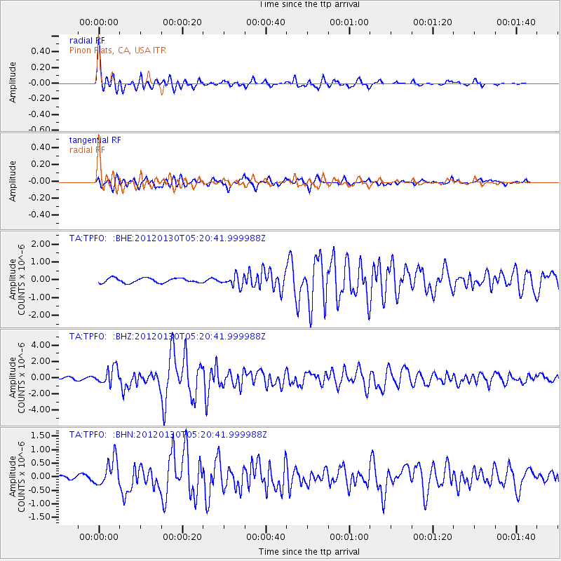
Signal To Noise
| Channel | StoN | STA | LTA |
| TA:TPFO: :BHZ:20120130T05:20:41.999988Z | 5.3230624 | 1.0348788E-6 | 1.9441417E-7 |
| TA:TPFO: :BHN:20120130T05:20:41.999988Z | 4.765159 | 5.0681473E-7 | 1.06358414E-7 |
| TA:TPFO: :BHE:20120130T05:20:41.999988Z | 2.3056188 | 3.0273324E-7 | 1.3130239E-7 |
| Arrivals |
| Ps | 1.9 SECOND |
| PpPs | 5.1 SECOND |
| PsPs/PpSs | 7.0 SECOND |


