You are here: Home > Network List > TA - USArray Transportable Network (new EarthScope stations) Stations List
> Station Q41A Truxton, MO, USA > Earthquake Result Viewer
Q41A Truxton, MO, USA - Earthquake Result Viewer
| Earthquake location: |
Near Coast Of Peru |
| Earthquake latitude/longitude: |
-14.2/-75.6 |
| Earthquake time(UTC): |
2012/01/30 (030) 05:11:00 GMT |
| Earthquake Depth: |
43 km |
| Earthquake Magnitude: |
6.3 MB, 5.9 MS, 6.4 MW, 6.4 MW |
| Earthquake Catalog/Contributor: |
WHDF/NEIC |
|
| Network: |
TA USArray Transportable Network (new EarthScope stations) |
| Station: |
Q41A Truxton, MO, USA |
| Lat/Lon: |
38.95 N/91.23 W |
| Elevation: |
191 m |
|
| Distance: |
54.8 deg |
| Az: |
345.138 deg |
| Baz: |
161.393 deg |
| Ray Param: |
0.06510762 |
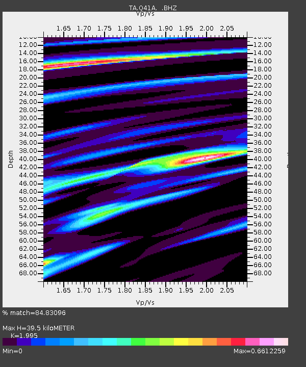
| Estimated Moho Depth: |
39.5 km |
| Estimated Crust Vp/Vs: |
2.00 |
| Assumed Crust Vp: |
6.498 km/s |
| Estimated Crust Vs: |
3.257 km/s |
| Estimated Crust Poisson's Ratio: |
0.33 |
|
| Radial Match: |
84.83096 % |
| Radial Bump: |
281 |
| Transverse Match: |
63.18602 % |
| Transverse Bump: |
400 |
| SOD ConfigId: |
436445 |
| Insert Time: |
2012-04-11 05:36:51.199 +0000 |
| GWidth: |
2.5 |
| Max Bumps: |
400 |
| Tol: |
0.001 |
|
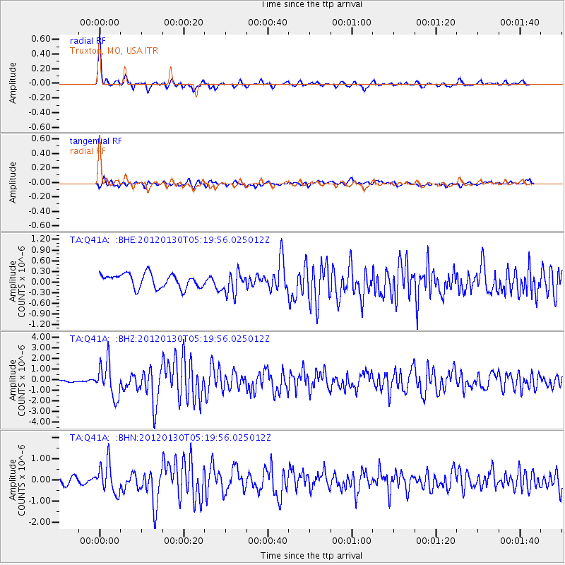
Signal To Noise
| Channel | StoN | STA | LTA |
| TA:Q41A: :BHZ:20120130T05:19:56.025012Z | 9.648093 | 1.6665408E-6 | 1.7273265E-7 |
| TA:Q41A: :BHN:20120130T05:19:56.025012Z | 4.115937 | 7.163469E-7 | 1.7404223E-7 |
| TA:Q41A: :BHE:20120130T05:19:56.025012Z | 1.5377061 | 3.0201872E-7 | 1.964086E-7 |
| Arrivals |
| Ps | 6.3 SECOND |
| PpPs | 17 SECOND |
| PsPs/PpSs | 24 SECOND |


