You are here: Home > Network List > TA - USArray Transportable Network (new EarthScope stations) Stations List
> Station H39A Augusta, WI, USA > Earthquake Result Viewer
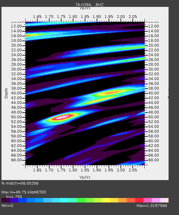
H39A Augusta, WI, USA - Earthquake Result Viewer
| Earthquake location: |
Near Coast Of Peru |
| Earthquake latitude/longitude: |
-14.2/-75.6 |
| Earthquake time(UTC): |
2012/01/30 (030) 05:11:00 GMT |
| Earthquake Depth: |
43 km |
| Earthquake Magnitude: |
6.3 MB, 5.9 MS, 6.4 MW, 6.4 MW |
| Earthquake Catalog/Contributor: |
WHDF/NEIC |
|
| Network: |
TA USArray Transportable Network (new EarthScope stations) |
| Station: |
H39A Augusta, WI, USA |
| Lat/Lon: |
44.68 N/91.28 W |
| Elevation: |
345 m |
|
| Distance: |
60.3 deg |
| Az: |
347.197 deg |
| Baz: |
162.465 deg |
| Ray Param: |
0.061553083 |
| Estimated Moho Depth: |
49.75 km |
| Estimated Crust Vp/Vs: |
1.75 |
| Assumed Crust Vp: |
6.571 km/s |
| Estimated Crust Vs: |
3.744 km/s |
| Estimated Crust Poisson's Ratio: |
0.26 |
|
| Radial Match: |
86.85286 % |
| Radial Bump: |
392 |
| Transverse Match: |
71.611786 % |
| Transverse Bump: |
400 |
| SOD ConfigId: |
436445 |
| Insert Time: |
2012-04-11 05:37:31.538 +0000 |
| GWidth: |
2.5 |
| Max Bumps: |
400 |
| Tol: |
0.001 |
|

Signal To Noise
| Channel | StoN | STA | LTA |
| TA:H39A: :BHZ:20120130T05:20:34.299976Z | 7.8654933 | 1.4427877E-6 | 1.8343259E-7 |
| TA:H39A: :BHN:20120130T05:20:34.299976Z | 4.1476073 | 7.398942E-7 | 1.783906E-7 |
| TA:H39A: :BHE:20120130T05:20:34.299976Z | 1.1495614 | 1.6167193E-7 | 1.4063794E-7 |
| Arrivals |
| Ps | 6.0 SECOND |
| PpPs | 20 SECOND |
| PsPs/PpSs | 26 SECOND |


