You are here: Home > Network List > TA - USArray Transportable Network (new EarthScope stations) Stations List
> Station E40A Wakefield, MI, USA > Earthquake Result Viewer
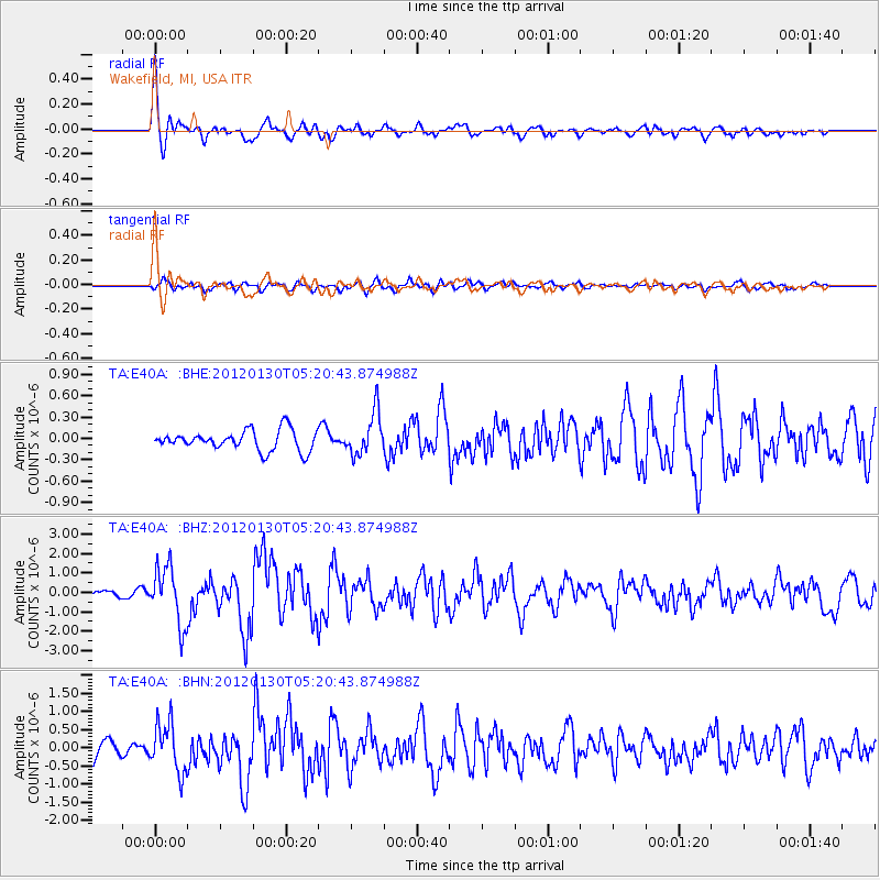
E40A Wakefield, MI, USA - Earthquake Result Viewer
*The percent match for this event was below the threshold and hence no stack was calculated.
| Earthquake location: |
Near Coast Of Peru |
| Earthquake latitude/longitude: |
-14.2/-75.6 |
| Earthquake time(UTC): |
2012/01/30 (030) 05:11:00 GMT |
| Earthquake Depth: |
43 km |
| Earthquake Magnitude: |
6.3 MB, 5.9 MS, 6.4 MW, 6.4 MW |
| Earthquake Catalog/Contributor: |
WHDF/NEIC |
|
| Network: |
TA USArray Transportable Network (new EarthScope stations) |
| Station: |
E40A Wakefield, MI, USA |
| Lat/Lon: |
46.44 N/89.90 W |
| Elevation: |
472 m |
|
| Distance: |
61.7 deg |
| Az: |
348.841 deg |
| Baz: |
164.248 deg |
| Ray Param: |
$rayparam |
*The percent match for this event was below the threshold and hence was not used in the summary stack. |
|
| Radial Match: |
77.34552 % |
| Radial Bump: |
400 |
| Transverse Match: |
67.4048 % |
| Transverse Bump: |
400 |
| SOD ConfigId: |
436445 |
| Insert Time: |
2012-04-11 05:40:27.312 +0000 |
| GWidth: |
2.5 |
| Max Bumps: |
400 |
| Tol: |
0.001 |
|
Signal To Noise
| Channel | StoN | STA | LTA |
| TA:E40A: :BHZ:20120130T05:20:43.874988Z | 9.039489 | 1.4752787E-6 | 1.6320378E-7 |
| TA:E40A: :BHN:20120130T05:20:43.874988Z | 2.329439 | 6.7574155E-7 | 2.9008768E-7 |
| TA:E40A: :BHE:20120130T05:20:43.874988Z | 2.1186311 | 2.9835346E-7 | 1.4082369E-7 |
| Arrivals |
| Ps | |
| PpPs | |
| PsPs/PpSs | |


