You are here: Home > Network List > TA - USArray Transportable Network (new EarthScope stations) Stations List
> Station H43A Windswept, Luxemburg, WI, USA > Earthquake Result Viewer
H43A Windswept, Luxemburg, WI, USA - Earthquake Result Viewer
| Earthquake location: |
Near Coast Of Peru |
| Earthquake latitude/longitude: |
-14.2/-75.6 |
| Earthquake time(UTC): |
2012/01/30 (030) 05:11:00 GMT |
| Earthquake Depth: |
43 km |
| Earthquake Magnitude: |
6.3 MB, 5.9 MS, 6.4 MW, 6.4 MW |
| Earthquake Catalog/Contributor: |
WHDF/NEIC |
|
| Network: |
TA USArray Transportable Network (new EarthScope stations) |
| Station: |
H43A Windswept, Luxemburg, WI, USA |
| Lat/Lon: |
44.47 N/87.77 W |
| Elevation: |
274 m |
|
| Distance: |
59.4 deg |
| Az: |
349.929 deg |
| Baz: |
166.295 deg |
| Ray Param: |
0.062127482 |
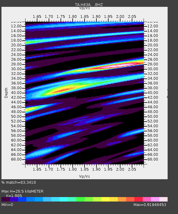
| Estimated Moho Depth: |
28.5 km |
| Estimated Crust Vp/Vs: |
1.99 |
| Assumed Crust Vp: |
6.53 km/s |
| Estimated Crust Vs: |
3.29 km/s |
| Estimated Crust Poisson's Ratio: |
0.33 |
|
| Radial Match: |
83.3418 % |
| Radial Bump: |
399 |
| Transverse Match: |
50.0518 % |
| Transverse Bump: |
400 |
| SOD ConfigId: |
436445 |
| Insert Time: |
2012-04-11 05:41:52.296 +0000 |
| GWidth: |
2.5 |
| Max Bumps: |
400 |
| Tol: |
0.001 |
|

Signal To Noise
| Channel | StoN | STA | LTA |
| TA:H43A: :BHZ:20120130T05:20:28.299976Z | 4.828094 | 1.5049644E-6 | 3.1170984E-7 |
| TA:H43A: :BHN:20120130T05:20:28.299976Z | 3.218901 | 6.749448E-7 | 2.0968176E-7 |
| TA:H43A: :BHE:20120130T05:20:28.299976Z | 0.9364306 | 2.6051114E-7 | 2.7819593E-7 |
| Arrivals |
| Ps | 4.5 SECOND |
| PpPs | 12 SECOND |
| PsPs/PpSs | 17 SECOND |


