You are here: Home > Network List > TA - USArray Transportable Network (new EarthScope stations) Stations List
> Station J43A Natural Harvest Farm, Hartford, WI, USA > Earthquake Result Viewer
J43A Natural Harvest Farm, Hartford, WI, USA - Earthquake Result Viewer
| Earthquake location: |
Near Coast Of Peru |
| Earthquake latitude/longitude: |
-14.2/-75.6 |
| Earthquake time(UTC): |
2012/01/30 (030) 05:11:00 GMT |
| Earthquake Depth: |
43 km |
| Earthquake Magnitude: |
6.3 MB, 5.9 MS, 6.4 MW, 6.4 MW |
| Earthquake Catalog/Contributor: |
WHDF/NEIC |
|
| Network: |
TA USArray Transportable Network (new EarthScope stations) |
| Station: |
J43A Natural Harvest Farm, Hartford, WI, USA |
| Lat/Lon: |
43.38 N/88.42 W |
| Elevation: |
322 m |
|
| Distance: |
58.5 deg |
| Az: |
349.088 deg |
| Baz: |
165.413 deg |
| Ray Param: |
0.062744945 |
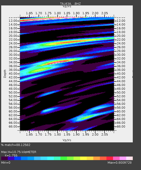
| Estimated Moho Depth: |
10.75 km |
| Estimated Crust Vp/Vs: |
1.75 |
| Assumed Crust Vp: |
6.571 km/s |
| Estimated Crust Vs: |
3.744 km/s |
| Estimated Crust Poisson's Ratio: |
0.26 |
|
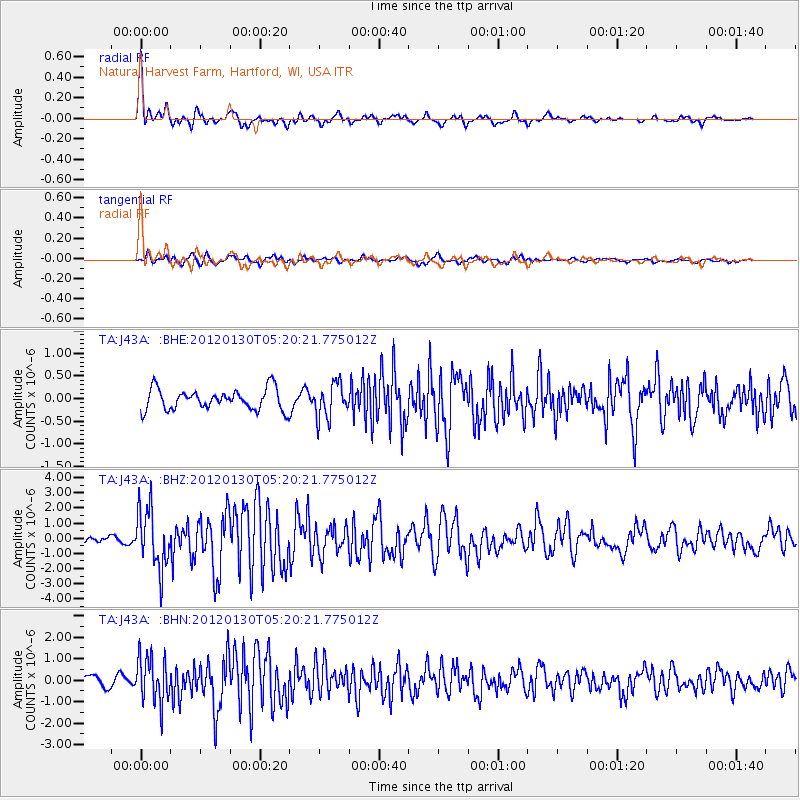
| Radial Match: |
88.12582 % |
| Radial Bump: |
400 |
| Transverse Match: |
60.520126 % |
| Transverse Bump: |
400 |
| SOD ConfigId: |
436445 |
| Insert Time: |
2012-04-11 05:42:18.314 +0000 |
| GWidth: |
2.5 |
| Max Bumps: |
400 |
| Tol: |
0.001 |
|
Signal To Noise
| Channel | StoN | STA | LTA |
| TA:J43A: :BHZ:20120130T05:20:21.775012Z | 6.9812245 | 1.9610466E-6 | 2.8090298E-7 |
| TA:J43A: :BHN:20120130T05:20:21.775012Z | 3.608137 | 1.0724152E-6 | 2.9722133E-7 |
| TA:J43A: :BHE:20120130T05:20:21.775012Z | 1.655322 | 3.8029222E-7 | 2.2973913E-7 |
| Arrivals |
| Ps | 1.3 SECOND |
| PpPs | 4.3 SECOND |
| PsPs/PpSs | 5.6 SECOND |


