You are here: Home > Network List > TA - USArray Transportable Network (new EarthScope stations) Stations List
> Station N43A Stutzman Family Farm, Minonk, IL, USA > Earthquake Result Viewer
N43A Stutzman Family Farm, Minonk, IL, USA - Earthquake Result Viewer
| Earthquake location: |
Near Coast Of Peru |
| Earthquake latitude/longitude: |
-14.2/-75.6 |
| Earthquake time(UTC): |
2012/01/30 (030) 05:11:00 GMT |
| Earthquake Depth: |
43 km |
| Earthquake Magnitude: |
6.3 MB, 5.9 MS, 6.4 MW, 6.4 MW |
| Earthquake Catalog/Contributor: |
WHDF/NEIC |
|
| Network: |
TA USArray Transportable Network (new EarthScope stations) |
| Station: |
N43A Stutzman Family Farm, Minonk, IL, USA |
| Lat/Lon: |
40.94 N/89.17 W |
| Elevation: |
215 m |
|
| Distance: |
56.2 deg |
| Az: |
347.684 deg |
| Baz: |
164.151 deg |
| Ray Param: |
0.06417476 |
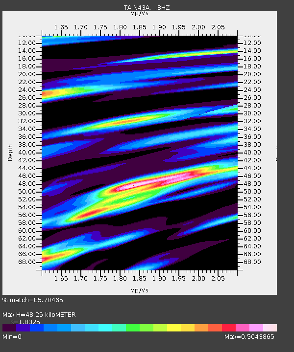
| Estimated Moho Depth: |
48.25 km |
| Estimated Crust Vp/Vs: |
1.83 |
| Assumed Crust Vp: |
6.498 km/s |
| Estimated Crust Vs: |
3.546 km/s |
| Estimated Crust Poisson's Ratio: |
0.29 |
|
| Radial Match: |
85.70465 % |
| Radial Bump: |
384 |
| Transverse Match: |
60.617203 % |
| Transverse Bump: |
400 |
| SOD ConfigId: |
436445 |
| Insert Time: |
2012-04-11 05:43:57.592 +0000 |
| GWidth: |
2.5 |
| Max Bumps: |
400 |
| Tol: |
0.001 |
|
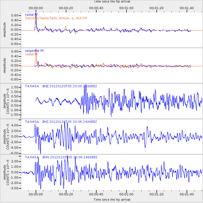
Signal To Noise
| Channel | StoN | STA | LTA |
| TA:N43A: :BHZ:20120130T05:20:06.249988Z | 9.089799 | 2.365344E-6 | 2.6021962E-7 |
| TA:N43A: :BHN:20120130T05:20:06.249988Z | 9.026036 | 1.4284003E-6 | 1.5825333E-7 |
| TA:N43A: :BHE:20120130T05:20:06.249988Z | 4.3832235 | 8.5973227E-7 | 1.9614157E-7 |
| Arrivals |
| Ps | 6.5 SECOND |
| PpPs | 20 SECOND |
| PsPs/PpSs | 27 SECOND |


