You are here: Home > Network List > TA - USArray Transportable Network (new EarthScope stations) Stations List
> Station Q47A Bedord North Lawrence Stars, Bedford, IN, USA > Earthquake Result Viewer
Q47A Bedord North Lawrence Stars, Bedford, IN, USA - Earthquake Result Viewer
| Earthquake location: |
Near Coast Of Peru |
| Earthquake latitude/longitude: |
-14.2/-75.6 |
| Earthquake time(UTC): |
2012/01/30 (030) 05:11:00 GMT |
| Earthquake Depth: |
43 km |
| Earthquake Magnitude: |
6.3 MB, 5.9 MS, 6.4 MW, 6.4 MW |
| Earthquake Catalog/Contributor: |
WHDF/NEIC |
|
| Network: |
TA USArray Transportable Network (new EarthScope stations) |
| Station: |
Q47A Bedord North Lawrence Stars, Bedford, IN, USA |
| Lat/Lon: |
38.94 N/86.43 W |
| Elevation: |
230 m |
|
| Distance: |
53.8 deg |
| Az: |
349.572 deg |
| Baz: |
166.991 deg |
| Ray Param: |
0.06577125 |
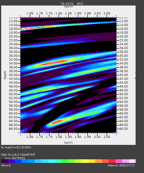
| Estimated Moho Depth: |
16.0 km |
| Estimated Crust Vp/Vs: |
1.61 |
| Assumed Crust Vp: |
6.444 km/s |
| Estimated Crust Vs: |
4.009 km/s |
| Estimated Crust Poisson's Ratio: |
0.18 |
|
| Radial Match: |
93.91994 % |
| Radial Bump: |
360 |
| Transverse Match: |
78.65227 % |
| Transverse Bump: |
400 |
| SOD ConfigId: |
436445 |
| Insert Time: |
2012-04-11 05:44:13.052 +0000 |
| GWidth: |
2.5 |
| Max Bumps: |
400 |
| Tol: |
0.001 |
|
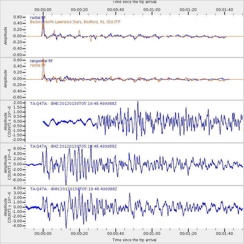
Signal To Noise
| Channel | StoN | STA | LTA |
| TA:Q47A: :BHZ:20120130T05:19:48.499988Z | 17.921381 | 2.9767673E-6 | 1.6610144E-7 |
| TA:Q47A: :BHN:20120130T05:19:48.499988Z | 8.110241 | 1.4021716E-6 | 1.7288902E-7 |
| TA:Q47A: :BHE:20120130T05:19:48.499988Z | 2.9549155 | 5.086044E-7 | 1.7212146E-7 |
| Arrivals |
| Ps | 1.6 SECOND |
| PpPs | 6.1 SECOND |
| PsPs/PpSs | 7.7 SECOND |


