You are here: Home > Network List > TA - USArray Transportable Network (new EarthScope stations) Stations List
> Station P45A Graceland, Paris, IL, USA > Earthquake Result Viewer
P45A Graceland, Paris, IL, USA - Earthquake Result Viewer
| Earthquake location: |
Near Coast Of Peru |
| Earthquake latitude/longitude: |
-14.2/-75.6 |
| Earthquake time(UTC): |
2012/01/30 (030) 05:11:00 GMT |
| Earthquake Depth: |
43 km |
| Earthquake Magnitude: |
6.3 MB, 5.9 MS, 6.4 MW, 6.4 MW |
| Earthquake Catalog/Contributor: |
WHDF/NEIC |
|
| Network: |
TA USArray Transportable Network (new EarthScope stations) |
| Station: |
P45A Graceland, Paris, IL, USA |
| Lat/Lon: |
39.53 N/87.74 W |
| Elevation: |
193 m |
|
| Distance: |
54.6 deg |
| Az: |
348.519 deg |
| Baz: |
165.545 deg |
| Ray Param: |
0.06525545 |
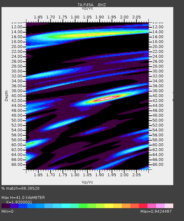
| Estimated Moho Depth: |
41.0 km |
| Estimated Crust Vp/Vs: |
1.92 |
| Assumed Crust Vp: |
6.444 km/s |
| Estimated Crust Vs: |
3.356 km/s |
| Estimated Crust Poisson's Ratio: |
0.31 |
|
| Radial Match: |
89.39528 % |
| Radial Bump: |
400 |
| Transverse Match: |
75.51015 % |
| Transverse Bump: |
400 |
| SOD ConfigId: |
436445 |
| Insert Time: |
2012-04-11 05:44:48.274 +0000 |
| GWidth: |
2.5 |
| Max Bumps: |
400 |
| Tol: |
0.001 |
|

Signal To Noise
| Channel | StoN | STA | LTA |
| TA:P45A: :BHZ:20120130T05:19:54.450Z | 15.3331175 | 2.6324096E-6 | 1.7168131E-7 |
| TA:P45A: :BHN:20120130T05:19:54.450Z | 4.652504 | 1.1689857E-6 | 2.5125948E-7 |
| TA:P45A: :BHE:20120130T05:19:54.450Z | 2.9837935 | 5.143044E-7 | 1.7236596E-7 |
| Arrivals |
| Ps | 6.1 SECOND |
| PpPs | 18 SECOND |
| PsPs/PpSs | 24 SECOND |


