You are here: Home > Network List > TA - USArray Transportable Network (new EarthScope stations) Stations List
> Station X47A Russelville, AR, USA > Earthquake Result Viewer
X47A Russelville, AR, USA - Earthquake Result Viewer
| Earthquake location: |
Near Coast Of Peru |
| Earthquake latitude/longitude: |
-14.2/-75.6 |
| Earthquake time(UTC): |
2012/01/30 (030) 05:11:00 GMT |
| Earthquake Depth: |
43 km |
| Earthquake Magnitude: |
6.3 MB, 5.9 MS, 6.4 MW, 6.4 MW |
| Earthquake Catalog/Contributor: |
WHDF/NEIC |
|
| Network: |
TA USArray Transportable Network (new EarthScope stations) |
| Station: |
X47A Russelville, AR, USA |
| Lat/Lon: |
34.52 N/87.86 W |
| Elevation: |
212 m |
|
| Distance: |
49.8 deg |
| Az: |
346.768 deg |
| Baz: |
164.402 deg |
| Ray Param: |
0.06837743 |
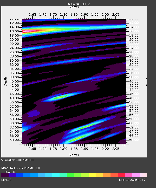
| Estimated Moho Depth: |
15.75 km |
| Estimated Crust Vp/Vs: |
1.60 |
| Assumed Crust Vp: |
6.476 km/s |
| Estimated Crust Vs: |
4.047 km/s |
| Estimated Crust Poisson's Ratio: |
0.18 |
|
| Radial Match: |
88.34318 % |
| Radial Bump: |
387 |
| Transverse Match: |
77.86812 % |
| Transverse Bump: |
400 |
| SOD ConfigId: |
436445 |
| Insert Time: |
2012-04-11 05:46:23.173 +0000 |
| GWidth: |
2.5 |
| Max Bumps: |
400 |
| Tol: |
0.001 |
|

Signal To Noise
| Channel | StoN | STA | LTA |
| TA:X47A: :BHZ:20120130T05:19:18.825Z | 8.457371 | 1.4228924E-6 | 1.6824286E-7 |
| TA:X47A: :BHN:20120130T05:19:18.825Z | 4.793883 | 6.7113234E-7 | 1.3999765E-7 |
| TA:X47A: :BHE:20120130T05:19:18.825Z | 1.5934622 | 1.7415972E-7 | 1.0929642E-7 |
| Arrivals |
| Ps | 1.6 SECOND |
| PpPs | 5.9 SECOND |
| PsPs/PpSs | 7.5 SECOND |


