You are here: Home > Network List > TA - USArray Transportable Network (new EarthScope stations) Stations List
> Station 150A Eclectic, AL, USA > Earthquake Result Viewer
150A Eclectic, AL, USA - Earthquake Result Viewer
| Earthquake location: |
Near Coast Of Peru |
| Earthquake latitude/longitude: |
-14.2/-75.6 |
| Earthquake time(UTC): |
2012/01/30 (030) 05:11:00 GMT |
| Earthquake Depth: |
43 km |
| Earthquake Magnitude: |
6.3 MB, 5.9 MS, 6.4 MW, 6.4 MW |
| Earthquake Catalog/Contributor: |
WHDF/NEIC |
|
| Network: |
TA USArray Transportable Network (new EarthScope stations) |
| Station: |
150A Eclectic, AL, USA |
| Lat/Lon: |
32.61 N/86.02 W |
| Elevation: |
145 m |
|
| Distance: |
47.6 deg |
| Az: |
348.1 deg |
| Baz: |
166.292 deg |
| Ray Param: |
0.069811165 |
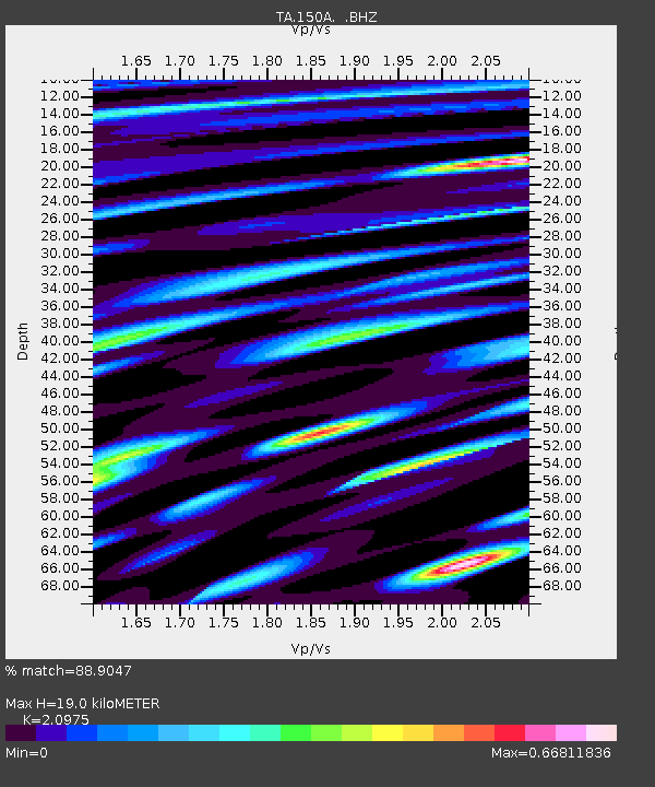
| Estimated Moho Depth: |
19.0 km |
| Estimated Crust Vp/Vs: |
2.10 |
| Assumed Crust Vp: |
6.565 km/s |
| Estimated Crust Vs: |
3.13 km/s |
| Estimated Crust Poisson's Ratio: |
0.35 |
|
| Radial Match: |
88.9047 % |
| Radial Bump: |
400 |
| Transverse Match: |
68.558136 % |
| Transverse Bump: |
400 |
| SOD ConfigId: |
436445 |
| Insert Time: |
2012-04-11 05:48:31.282 +0000 |
| GWidth: |
2.5 |
| Max Bumps: |
400 |
| Tol: |
0.001 |
|
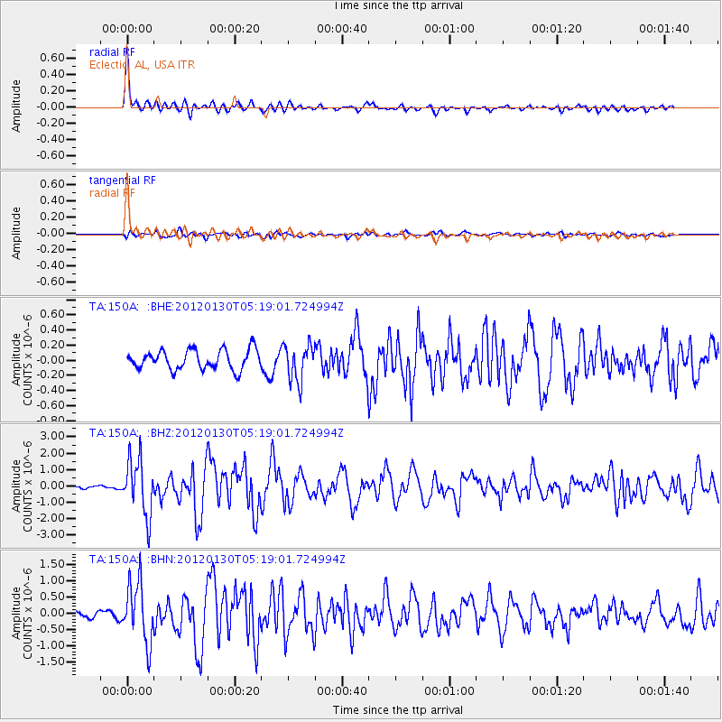
Signal To Noise
| Channel | StoN | STA | LTA |
| TA:150A: :BHZ:20120130T05:19:01.724994Z | 12.266786 | 1.7148157E-6 | 1.3979339E-7 |
| TA:150A: :BHN:20120130T05:19:01.724994Z | 8.0607395 | 9.257051E-7 | 1.1484121E-7 |
| TA:150A: :BHE:20120130T05:19:01.724994Z | 1.9169546 | 2.4485334E-7 | 1.2773037E-7 |
| Arrivals |
| Ps | 3.4 SECOND |
| PpPs | 8.5 SECOND |
| PsPs/PpSs | 12 SECOND |


