You are here: Home > Network List > TA - USArray Transportable Network (new EarthScope stations) Stations List
> Station 250A Grady, AL, USA > Earthquake Result Viewer
250A Grady, AL, USA - Earthquake Result Viewer
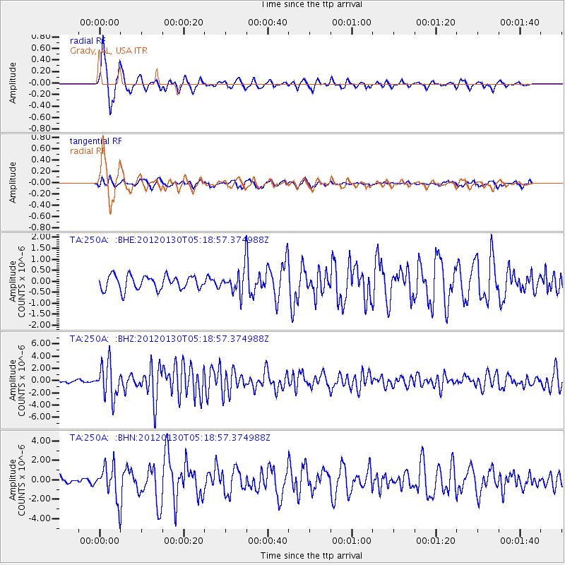
| Earthquake location: |
Near Coast Of Peru |
| Earthquake latitude/longitude: |
-14.2/-75.6 |
| Earthquake time(UTC): |
2012/01/30 (030) 05:11:00 GMT |
| Earthquake Depth: |
43 km |
| Earthquake Magnitude: |
6.3 MB, 5.9 MS, 6.4 MW, 6.4 MW |
| Earthquake Catalog/Contributor: |
WHDF/NEIC |
|
| Network: |
TA USArray Transportable Network (new EarthScope stations) |
| Station: |
250A Grady, AL, USA |
| Lat/Lon: |
31.98 N/86.27 W |
| Elevation: |
152 m |
|
| Distance: |
47.0 deg |
| Az: |
347.62 deg |
| Baz: |
165.835 deg |
| Ray Param: |
0.07017421 |
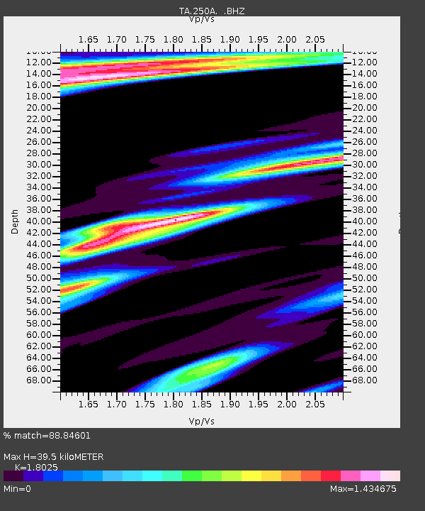
| Estimated Moho Depth: |
39.5 km |
| Estimated Crust Vp/Vs: |
1.80 |
| Assumed Crust Vp: |
6.187 km/s |
| Estimated Crust Vs: |
3.432 km/s |
| Estimated Crust Poisson's Ratio: |
0.28 |
|
| Radial Match: |
88.84601 % |
| Radial Bump: |
346 |
| Transverse Match: |
63.6987 % |
| Transverse Bump: |
373 |
| SOD ConfigId: |
436445 |
| Insert Time: |
2012-04-11 05:48:47.340 +0000 |
| GWidth: |
2.5 |
| Max Bumps: |
400 |
| Tol: |
0.001 |
|
Signal To Noise
| Channel | StoN | STA | LTA |
| TA:250A: :BHZ:20120130T05:18:57.374988Z | 18.96135 | 2.8243471E-6 | 1.4895285E-7 |
| TA:250A: :BHN:20120130T05:18:57.374988Z | 5.7287555 | 1.7525681E-6 | 3.0592474E-7 |
| TA:250A: :BHE:20120130T05:18:57.374988Z | 1.8227365 | 5.779357E-7 | 3.1707035E-7 |
| Arrivals |
| Ps | 5.4 SECOND |
| PpPs | 17 SECOND |
| PsPs/PpSs | 22 SECOND |


