You are here: Home > Network List > BK - Berkeley Digital Seismograph Network Stations List
> Station HUMO Hull Mountain, OR > Earthquake Result Viewer
HUMO Hull Mountain, OR - Earthquake Result Viewer
| Earthquake location: |
Vanuatu Islands |
| Earthquake latitude/longitude: |
-17.8/167.1 |
| Earthquake time(UTC): |
2012/02/02 (033) 13:34:40 GMT |
| Earthquake Depth: |
23 km |
| Earthquake Magnitude: |
6.5 MB, 6.9 MS, 7.1 MW, 7.1 MW |
| Earthquake Catalog/Contributor: |
WHDF/NEIC |
|
| Network: |
BK Berkeley Digital Seismograph Network |
| Station: |
HUMO Hull Mountain, OR |
| Lat/Lon: |
42.61 N/122.96 W |
| Elevation: |
555 m |
|
| Distance: |
87.9 deg |
| Az: |
43.933 deg |
| Baz: |
243.536 deg |
| Ray Param: |
0.042949792 |
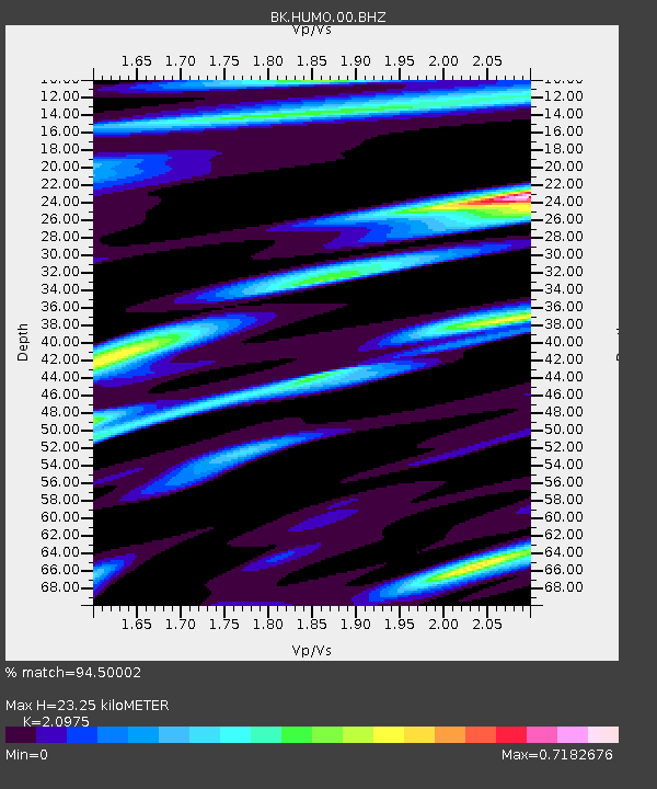
| Estimated Moho Depth: |
23.25 km |
| Estimated Crust Vp/Vs: |
2.10 |
| Assumed Crust Vp: |
6.522 km/s |
| Estimated Crust Vs: |
3.109 km/s |
| Estimated Crust Poisson's Ratio: |
0.35 |
|
| Radial Match: |
94.50002 % |
| Radial Bump: |
400 |
| Transverse Match: |
89.79473 % |
| Transverse Bump: |
400 |
| SOD ConfigId: |
436445 |
| Insert Time: |
2012-04-11 06:16:12.072 +0000 |
| GWidth: |
2.5 |
| Max Bumps: |
400 |
| Tol: |
0.001 |
|

Signal To Noise
| Channel | StoN | STA | LTA |
| BK:HUMO:00:BHZ:20120202T13:46:56.944983Z | 22.132868 | 6.3778075E-6 | 2.8816E-7 |
| BK:HUMO:00:BHN:20120202T13:46:56.944983Z | 6.8278556 | 1.1712978E-6 | 1.7154694E-7 |
| BK:HUMO:00:BHE:20120202T13:46:56.944983Z | 9.959747 | 1.7920179E-6 | 1.7992603E-7 |
| Arrivals |
| Ps | 4.0 SECOND |
| PpPs | 11 SECOND |
| PsPs/PpSs | 15 SECOND |


