You are here: Home > Network List > CI - Caltech Regional Seismic Network Stations List
> Station SHO Shoshone, CA, USA > Earthquake Result Viewer
SHO Shoshone, CA, USA - Earthquake Result Viewer
| Earthquake location: |
Vanuatu Islands |
| Earthquake latitude/longitude: |
-17.8/167.1 |
| Earthquake time(UTC): |
2012/02/02 (033) 13:34:40 GMT |
| Earthquake Depth: |
23 km |
| Earthquake Magnitude: |
6.5 MB, 6.9 MS, 7.1 MW, 7.1 MW |
| Earthquake Catalog/Contributor: |
WHDF/NEIC |
|
| Network: |
CI Caltech Regional Seismic Network |
| Station: |
SHO Shoshone, CA, USA |
| Lat/Lon: |
35.90 N/116.28 W |
| Elevation: |
451 m |
|
| Distance: |
89.9 deg |
| Az: |
52.165 deg |
| Baz: |
247.914 deg |
| Ray Param: |
0.041709445 |
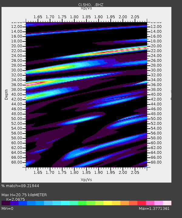
| Estimated Moho Depth: |
20.75 km |
| Estimated Crust Vp/Vs: |
2.07 |
| Assumed Crust Vp: |
6.276 km/s |
| Estimated Crust Vs: |
3.035 km/s |
| Estimated Crust Poisson's Ratio: |
0.35 |
|
| Radial Match: |
89.21944 % |
| Radial Bump: |
400 |
| Transverse Match: |
83.62757 % |
| Transverse Bump: |
400 |
| SOD ConfigId: |
436445 |
| Insert Time: |
2012-04-11 06:17:32.708 +0000 |
| GWidth: |
2.5 |
| Max Bumps: |
400 |
| Tol: |
0.001 |
|
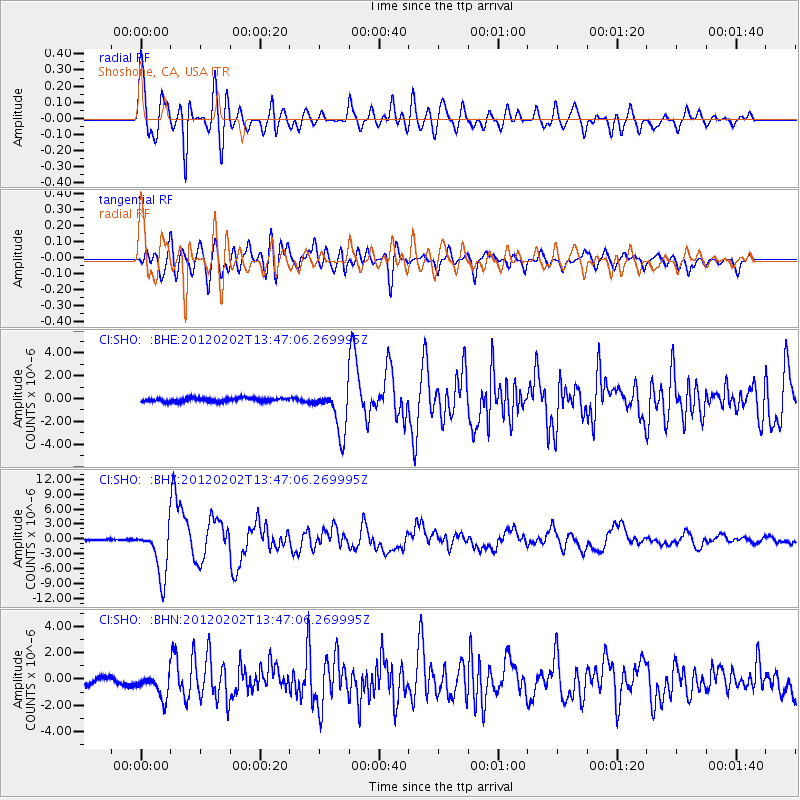
Signal To Noise
| Channel | StoN | STA | LTA |
| CI:SHO: :BHZ:20120202T13:47:06.269995Z | 27.132078 | 5.0330527E-6 | 1.8550193E-7 |
| CI:SHO: :BHN:20120202T13:47:06.269995Z | 4.2840962 | 9.4236884E-7 | 2.1996912E-7 |
| CI:SHO: :BHE:20120202T13:47:06.269995Z | 11.915486 | 1.9474867E-6 | 1.6344164E-7 |
| Arrivals |
| Ps | 3.6 SECOND |
| PpPs | 10.0 SECOND |
| PsPs/PpSs | 14 SECOND |


