You are here: Home > Network List > CI - Caltech Regional Seismic Network Stations List
> Station SLA SLA, Trona, CA, USA > Earthquake Result Viewer
SLA SLA, Trona, CA, USA - Earthquake Result Viewer
| Earthquake location: |
Vanuatu Islands |
| Earthquake latitude/longitude: |
-17.8/167.1 |
| Earthquake time(UTC): |
2012/02/02 (033) 13:34:40 GMT |
| Earthquake Depth: |
23 km |
| Earthquake Magnitude: |
6.5 MB, 6.9 MS, 7.1 MW, 7.1 MW |
| Earthquake Catalog/Contributor: |
WHDF/NEIC |
|
| Network: |
CI Caltech Regional Seismic Network |
| Station: |
SLA SLA, Trona, CA, USA |
| Lat/Lon: |
35.89 N/117.28 W |
| Elevation: |
1174 m |
|
| Distance: |
89.1 deg |
| Az: |
51.861 deg |
| Baz: |
247.323 deg |
| Ray Param: |
0.042043697 |
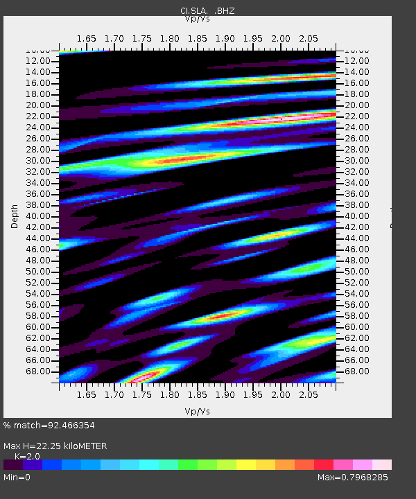
| Estimated Moho Depth: |
22.25 km |
| Estimated Crust Vp/Vs: |
2.00 |
| Assumed Crust Vp: |
6.276 km/s |
| Estimated Crust Vs: |
3.138 km/s |
| Estimated Crust Poisson's Ratio: |
0.33 |
|
| Radial Match: |
92.466354 % |
| Radial Bump: |
400 |
| Transverse Match: |
89.46586 % |
| Transverse Bump: |
400 |
| SOD ConfigId: |
436445 |
| Insert Time: |
2012-04-11 06:19:02.496 +0000 |
| GWidth: |
2.5 |
| Max Bumps: |
400 |
| Tol: |
0.001 |
|
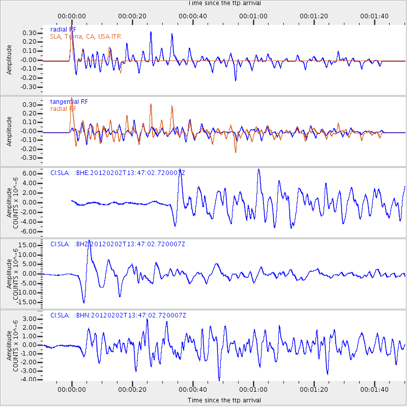
Signal To Noise
| Channel | StoN | STA | LTA |
| CI:SLA: :BHZ:20120202T13:47:02.720007Z | 27.682842 | 6.0868424E-6 | 2.198778E-7 |
| CI:SLA: :BHN:20120202T13:47:02.720007Z | 2.7764003 | 4.2740717E-7 | 1.5394292E-7 |
| CI:SLA: :BHE:20120202T13:47:02.720007Z | 9.357971 | 1.8834638E-6 | 2.0126839E-7 |
| Arrivals |
| Ps | 3.6 SECOND |
| PpPs | 10 SECOND |
| PsPs/PpSs | 14 SECOND |


