You are here: Home > Network List > CI - Caltech Regional Seismic Network Stations List
> Station RRX Rimrock Road, Barstow, CA, USA > Earthquake Result Viewer
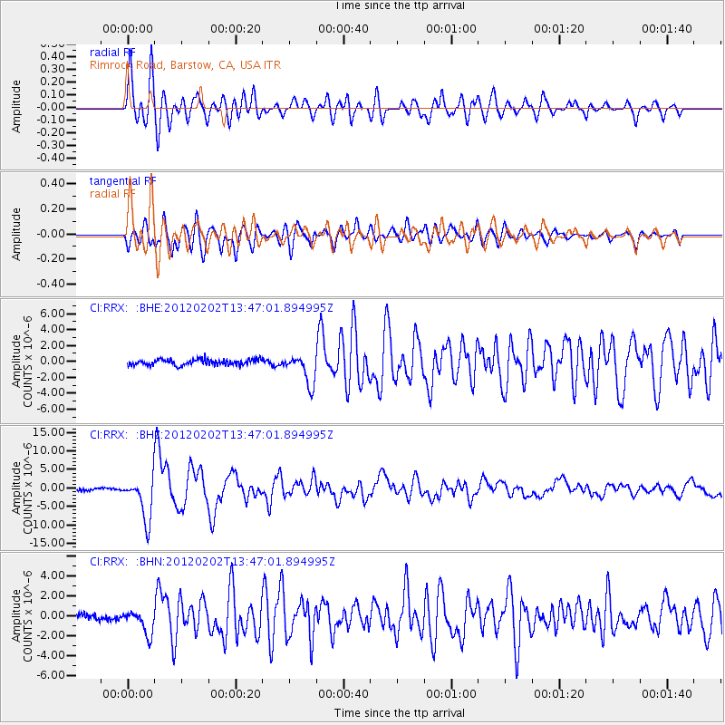
RRX Rimrock Road, Barstow, CA, USA - Earthquake Result Viewer
| Earthquake location: |
Vanuatu Islands |
| Earthquake latitude/longitude: |
-17.8/167.1 |
| Earthquake time(UTC): |
2012/02/02 (033) 13:34:40 GMT |
| Earthquake Depth: |
23 km |
| Earthquake Magnitude: |
6.5 MB, 6.9 MS, 7.1 MW, 7.1 MW |
| Earthquake Catalog/Contributor: |
WHDF/NEIC |
|
| Network: |
CI Caltech Regional Seismic Network |
| Station: |
RRX Rimrock Road, Barstow, CA, USA |
| Lat/Lon: |
34.88 N/117.00 W |
| Elevation: |
439 m |
|
| Distance: |
89.0 deg |
| Az: |
52.887 deg |
| Baz: |
247.505 deg |
| Ray Param: |
0.042169806 |
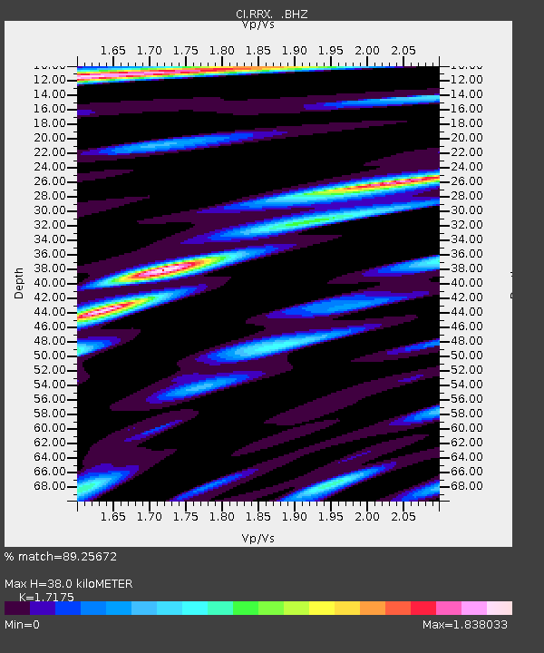
| Estimated Moho Depth: |
38.0 km |
| Estimated Crust Vp/Vs: |
1.72 |
| Assumed Crust Vp: |
6.276 km/s |
| Estimated Crust Vs: |
3.654 km/s |
| Estimated Crust Poisson's Ratio: |
0.24 |
|
| Radial Match: |
89.25672 % |
| Radial Bump: |
400 |
| Transverse Match: |
87.5286 % |
| Transverse Bump: |
400 |
| SOD ConfigId: |
436445 |
| Insert Time: |
2012-04-11 06:21:21.794 +0000 |
| GWidth: |
2.5 |
| Max Bumps: |
400 |
| Tol: |
0.001 |
|
Signal To Noise
| Channel | StoN | STA | LTA |
| CI:RRX: :BHZ:20120202T13:47:01.894995Z | 15.417777 | 5.9015715E-6 | 3.8277705E-7 |
| CI:RRX: :BHN:20120202T13:47:01.894995Z | 3.357099 | 1.2360113E-6 | 3.6817835E-7 |
| CI:RRX: :BHE:20120202T13:47:01.894995Z | 5.342614 | 1.9151137E-6 | 3.5846003E-7 |
| Arrivals |
| Ps | 4.4 SECOND |
| PpPs | 16 SECOND |
| PsPs/PpSs | 21 SECOND |


