You are here: Home > Network List > CI - Caltech Regional Seismic Network Stations List
> Station EDW2 EDW2, Mojave, CA, USA > Earthquake Result Viewer
EDW2 EDW2, Mojave, CA, USA - Earthquake Result Viewer
| Earthquake location: |
Vanuatu Islands |
| Earthquake latitude/longitude: |
-17.8/167.1 |
| Earthquake time(UTC): |
2012/02/02 (033) 13:34:40 GMT |
| Earthquake Depth: |
23 km |
| Earthquake Magnitude: |
6.5 MB, 6.9 MS, 7.1 MW, 7.1 MW |
| Earthquake Catalog/Contributor: |
WHDF/NEIC |
|
| Network: |
CI Caltech Regional Seismic Network |
| Station: |
EDW2 EDW2, Mojave, CA, USA |
| Lat/Lon: |
34.88 N/117.99 W |
| Elevation: |
772 m |
|
| Distance: |
88.2 deg |
| Az: |
52.564 deg |
| Baz: |
246.929 deg |
| Ray Param: |
0.04272908 |
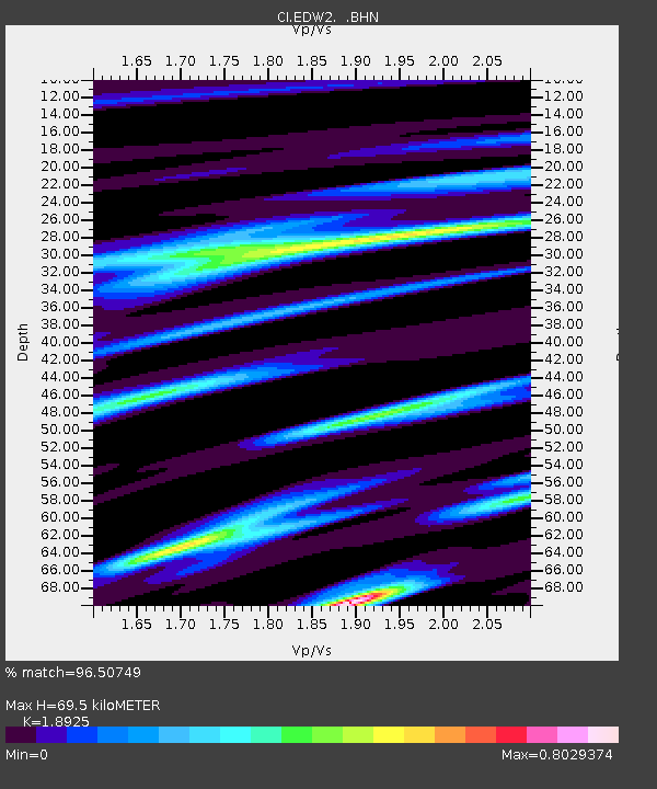
| Estimated Moho Depth: |
69.5 km |
| Estimated Crust Vp/Vs: |
1.89 |
| Assumed Crust Vp: |
6.276 km/s |
| Estimated Crust Vs: |
3.316 km/s |
| Estimated Crust Poisson's Ratio: |
0.31 |
|
| Radial Match: |
96.50749 % |
| Radial Bump: |
260 |
| Transverse Match: |
90.54966 % |
| Transverse Bump: |
345 |
| SOD ConfigId: |
436445 |
| Insert Time: |
2012-04-11 06:22:55.457 +0000 |
| GWidth: |
2.5 |
| Max Bumps: |
400 |
| Tol: |
0.001 |
|
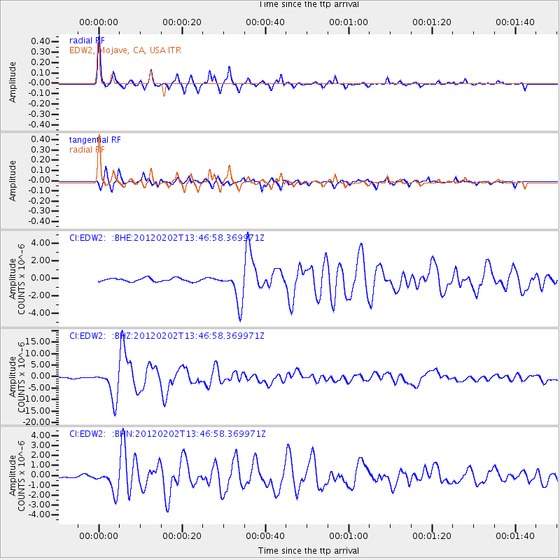
Signal To Noise
| Channel | StoN | STA | LTA |
| CI:EDW2: :BHZ:20120202T13:46:58.369971Z | 28.109005 | 6.7282144E-6 | 2.3936153E-7 |
| CI:EDW2: :BHN:20120202T13:46:58.369971Z | 8.699987 | 1.1343437E-6 | 1.3038452E-7 |
| CI:EDW2: :BHE:20120202T13:46:58.369971Z | 9.807032 | 1.934728E-6 | 1.972797E-7 |
| Arrivals |
| Ps | 10 SECOND |
| PpPs | 31 SECOND |
| PsPs/PpSs | 41 SECOND |


