You are here: Home > Network List > X812 - Deep Structure of Three Continental Sutures in Eastern North America Stations List
> Station QM28 6 mile checkpoint, Maine, USA > Earthquake Result Viewer
QM28 6 mile checkpoint, Maine, USA - Earthquake Result Viewer
| Earthquake location: |
Vancouver Island, Canada Region |
| Earthquake latitude/longitude: |
49.8/-127.4 |
| Earthquake time(UTC): |
2014/04/24 (114) 03:10:13 GMT |
| Earthquake Depth: |
11 km |
| Earthquake Magnitude: |
6.7 MWP, 6.7 MI |
| Earthquake Catalog/Contributor: |
NEIC PDE/NEIC COMCAT |
|
| Network: |
X8 Deep Structure of Three Continental Sutures in Eastern North America |
| Station: |
QM28 6 mile checkpoint, Maine, USA |
| Lat/Lon: |
46.64 N/68.53 W |
| Elevation: |
212 m |
|
| Distance: |
38.5 deg |
| Az: |
71.465 deg |
| Baz: |
297.036 deg |
| Ray Param: |
0.07553195 |
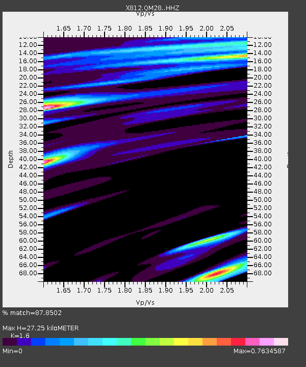
| Estimated Moho Depth: |
27.25 km |
| Estimated Crust Vp/Vs: |
1.60 |
| Assumed Crust Vp: |
6.419 km/s |
| Estimated Crust Vs: |
4.012 km/s |
| Estimated Crust Poisson's Ratio: |
0.18 |
|
| Radial Match: |
87.8502 % |
| Radial Bump: |
350 |
| Transverse Match: |
79.336815 % |
| Transverse Bump: |
400 |
| SOD ConfigId: |
3390531 |
| Insert Time: |
2019-04-11 14:32:42.302 +0000 |
| GWidth: |
2.5 |
| Max Bumps: |
400 |
| Tol: |
0.001 |
|

Signal To Noise
| Channel | StoN | STA | LTA |
| X8:QM28: :HHZ:20140424T03:17:04.765005Z | 10.135051 | 3.5589132E-6 | 3.5114903E-7 |
| X8:QM28: :HHN:20140424T03:17:04.765005Z | 4.4481645 | 1.1881897E-6 | 2.671191E-7 |
| X8:QM28: :HHE:20140424T03:17:04.765005Z | 3.19336 | 1.6415397E-6 | 5.140478E-7 |
| Arrivals |
| Ps | 2.8 SECOND |
| PpPs | 10 SECOND |
| PsPs/PpSs | 13 SECOND |


