You are here: Home > Network List > X812 - Deep Structure of Three Continental Sutures in Eastern North America Stations List
> Station QM34 Ferme Vifranc, St-Pamphile, Quebec, Canada > Earthquake Result Viewer
QM34 Ferme Vifranc, St-Pamphile, Quebec, Canada - Earthquake Result Viewer
| Earthquake location: |
Vancouver Island, Canada Region |
| Earthquake latitude/longitude: |
49.8/-127.4 |
| Earthquake time(UTC): |
2014/04/24 (114) 03:10:13 GMT |
| Earthquake Depth: |
11 km |
| Earthquake Magnitude: |
6.7 MWP, 6.7 MI |
| Earthquake Catalog/Contributor: |
NEIC PDE/NEIC COMCAT |
|
| Network: |
X8 Deep Structure of Three Continental Sutures in Eastern North America |
| Station: |
QM34 Ferme Vifranc, St-Pamphile, Quebec, Canada |
| Lat/Lon: |
47.02 N/69.83 W |
| Elevation: |
374 m |
|
| Distance: |
37.5 deg |
| Az: |
71.556 deg |
| Baz: |
296.159 deg |
| Ray Param: |
0.07609306 |
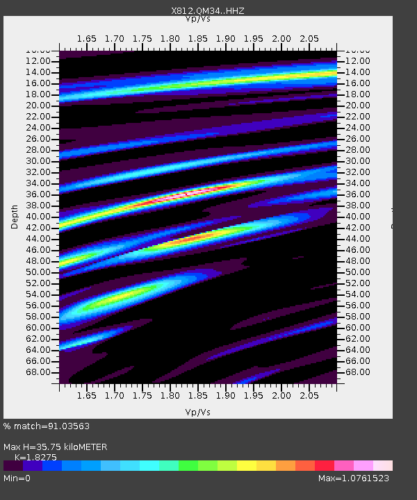
| Estimated Moho Depth: |
35.75 km |
| Estimated Crust Vp/Vs: |
1.83 |
| Assumed Crust Vp: |
6.419 km/s |
| Estimated Crust Vs: |
3.513 km/s |
| Estimated Crust Poisson's Ratio: |
0.29 |
|
| Radial Match: |
91.03563 % |
| Radial Bump: |
320 |
| Transverse Match: |
75.07147 % |
| Transverse Bump: |
400 |
| SOD ConfigId: |
3390531 |
| Insert Time: |
2019-04-11 14:32:43.894 +0000 |
| GWidth: |
2.5 |
| Max Bumps: |
400 |
| Tol: |
0.001 |
|
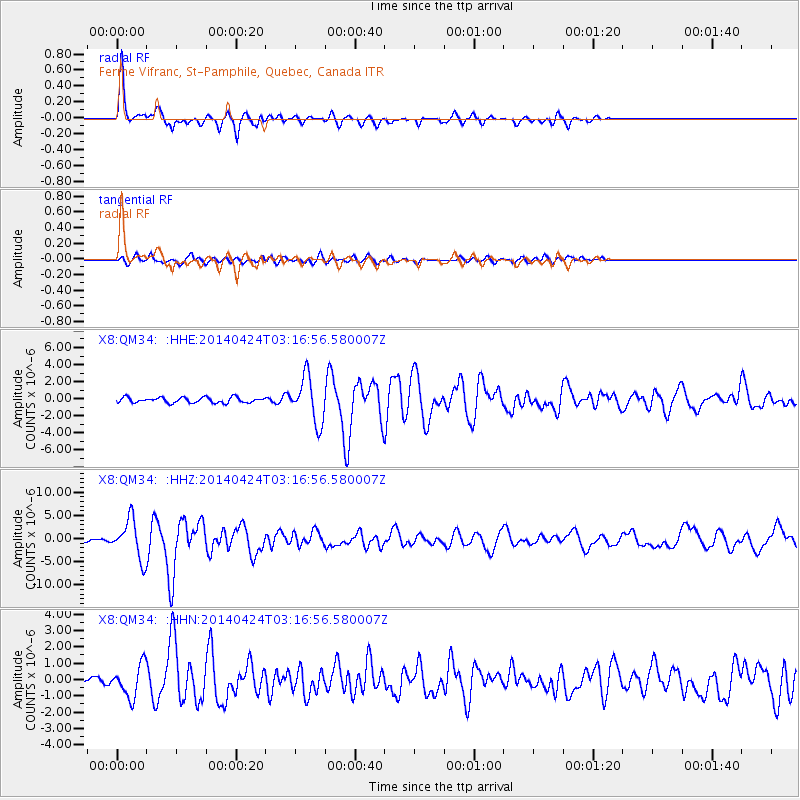
Signal To Noise
| Channel | StoN | STA | LTA |
| X8:QM34: :HHZ:20140424T03:16:56.580007Z | 13.3020115 | 4.2183738E-6 | 3.1712298E-7 |
| X8:QM34: :HHN:20140424T03:16:56.580007Z | 4.021475 | 9.875693E-7 | 2.455739E-7 |
| X8:QM34: :HHE:20140424T03:16:56.580007Z | 7.8482823 | 2.4968301E-6 | 3.1813715E-7 |
| Arrivals |
| Ps | 4.9 SECOND |
| PpPs | 15 SECOND |
| PsPs/PpSs | 20 SECOND |


